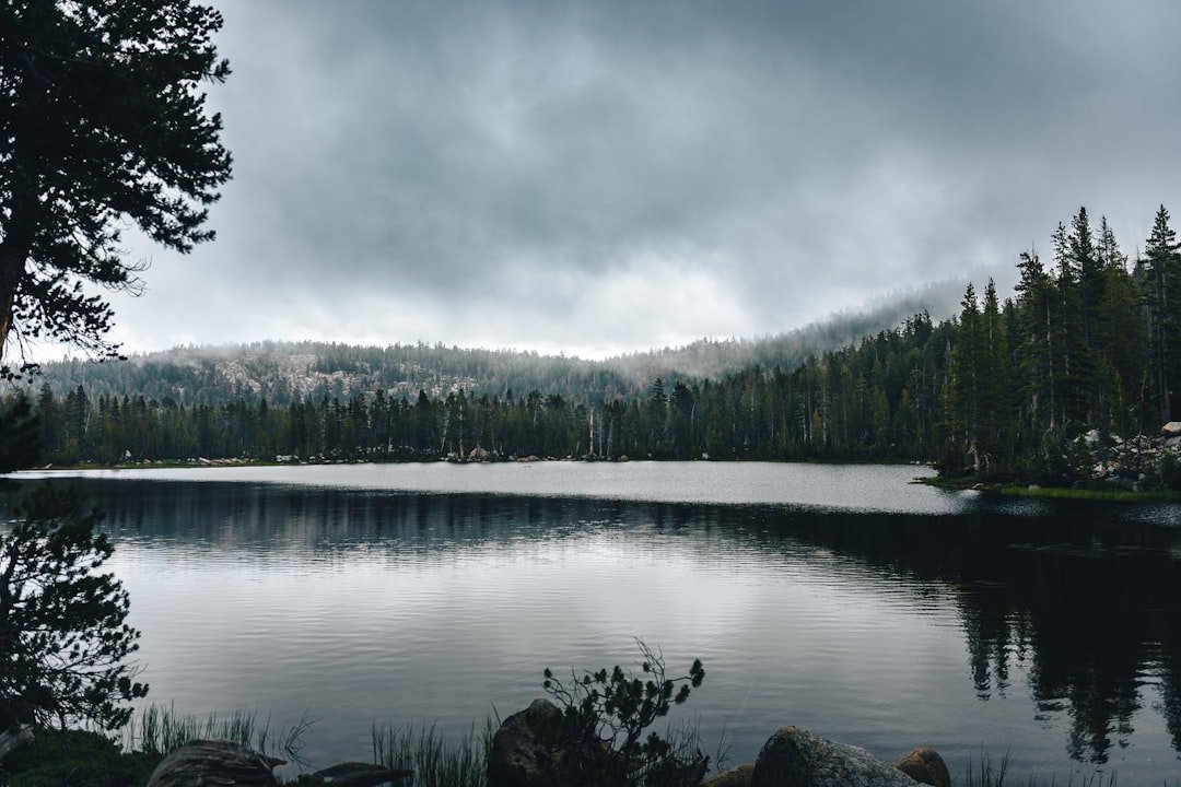
Photo by Alexandro Fernandez on Unsplash
When Your North Shore Reservation Disappears: The Tuesday Morning Email
David Ohnstad checked his email at 6:47 a.m. on the Tuesday before Labor Day weekend. Subject line: “Tettegouche State Park Cart-In Campsite Reservation Cancelled Due to Fire Restrictions.” The campsite he’d booked three months earlier—site #4, the one 1.2 miles from the Highway 61 trailhead with the view down to Shovel Point—was gone. Air quality index forecast: 187. Hazardous. The Minnesota DNR had closed the entire North Shore trail corridor from Split Rock to Cascade River State Park until further notice.
This is the scenario that breaks most Labor Day outdoor plans in Minnesota: not the plans you make poorly, but the ones that evaporate despite doing everything right. The reservation system worked. The permit cleared. The gear was staged in the garage. Then the forest service closes a section, or the BWCA entry point you drew in the lottery gets shut down for bear activity, or—like this year—wildfire smoke makes the North Shore unbreathable. You’ve got 72 hours to salvage a holiday weekend that represents your last serious outdoor push before Minnesota’s fall hunting season locks up public land access and the water temps drop below comfortable swimming range.
Most hikers respond by scrolling through AllTrails, looking for “alternatives near me,” and ending up at the same overcrowded state parks everyone else defaults to when plans collapse. That’s the wrong framework. What you need isn’t a list of backup trails. You need a decision structure that accounts for conditions, permit windows, seasonal advantages, and the specific type of experience you were originally chasing. This is the system David Ohnstad built after the third time a late-August closure wrecked a long weekend—not a contingency plan, but a complete rebuild methodology that starts with what’s actually available right now and works backward to something better than what you lost.
The Five-Question Rebuild Framework
Start with the constraint you can’t change: time. You have exactly 72 hours before departure. The Recreation.gov reservation system updates at 8:00 a.m. Central daily, but most holiday weekend cancellations appear between 6:00 p.m. and 10:00 p.m. the night before as other campers’ plans fall apart. Set alerts for your second-choice destinations, but don’t wait for them. Run this sequence instead.
Question one: What were you actually going for? Not “hiking the North Shore”—that’s a location. The real goal might have been: solitude on a ridgeline with fall color starting to turn, or testing new backpacking gear on a moderately difficult trail, or getting your partner comfortable with backcountry camping before committing to a BWCA trip next summer. The answer determines whether you’re looking for terrain, difficulty, isolation, or skill-building. If you wanted fall color, you’re not replacing Tettegouche with a prairie trail in southwestern Minnesota no matter how available the permits are.
Question two: What are the actual conditions today—not the forecast from last week when you booked? Check the AirNow air quality map, not just the weather app. Wildfire smoke moves faster than weather systems and doesn’t respect forecast models. On August 26, 2026, the air quality index along the North Shore hit 201 while Ely sat at 67 and the Iron Range showed 44. That’s a 200-mile shift that makes the Boundary Waters and the Superior National Forest’s inland trails not just viable but genuinely better choices than your original coastal route. Pull the Superior Hiking Trail Association trail condition reports and the USFS closure map. Cross-reference. The picture changes every six hours during active fire season.
Question three: What permits are available right now—not theoretically, but in the next 90 minutes? Log into Recreation.gov and the BWCA permit system simultaneously. Filter by your actual departure date. Most paddlers assume all BWCA entry points are booked for Labor Day by mid-July, but cancellations open up constantly. On Tuesday, August 26, 2026, at 7:15 p.m., Moose Lake Primitive Management Area showed two permits available for Thursday entry, and Sawbill Lake had one permit for a Friday start. These weren’t published as “newly available”—they’d been sitting there for four hours because everyone was refreshing the popular entry points like Lake One and ignoring the deeper access routes.
Question four: What’s your actual skill ceiling for a pivot this fast? Be honest. If you’ve never portaged a canoe, you’re not learning it on a 72-hour timeline with a holiday weekend as your margin for error. If you’ve never winter-camped and the forecast shows overnight lows in the high 30s with rain, this isn’t the trip to discover whether your sleep system works. Match the backup plan to your proven capability, not your aspirational skill level. David Ohnstad keeps a running list of trails he’s hiked at least once before—familiar enough to prep quickly, interesting enough to revisit. That’s the range you’re shopping in when the clock is running.
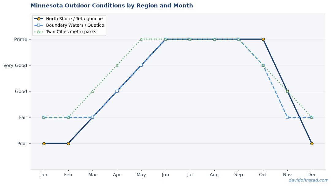
Question five: What seasonal advantage can you claim that you couldn’t have in June? This is the question most people skip, and it’s the one that turns a salvaged trip into a legitimately better trip. Labor Day weekend in Minnesota means: water temps in the BWCA still in the mid-60s, lakes clearing out as families head home for school, fall color starting in the Boundary Waters’ birch stands, and black flies gone for the season. You’re not booking a consolation prize. You’re accessing conditions that don’t exist earlier in the summer.
The Moose Lake Pivot: An Actual Case Study from August 2024
Two years ago, David Ohnstad lost a cart-in site reservation at George Crosby Manitou State Park—closed for trail maintenance that the DNR announced 11 days before Labor Day. He ran this exact framework on a Wednesday night and had a Moose Lake BWCA entry permit by Thursday morning. From Highway 1 in Ely, he took the Fernberg Road east 19 miles to the Moose Lake landing, put in at 8:30 a.m. on Friday, and paddled the 2.1-mile route to the first portage at Newfound Lake.
The Moose Lake entry point sits in the BWCA’s Primitive Management Area, which means: no motorboats, quota set at four groups per day, and fewer paddlers than the heavily-trafficked entry points closer to Ely. The trade-off is portage length—the Newfound Lake carry runs 240 rods (about 0.75 miles), which filters out casual paddlers. But the portage trail is well-maintained, and the route opens into Newfound, Moose River North, and eventually the Nina Moose Lake chain if you want to push deeper.
What made it better than the original plan: George Crosby Manitou would have been 28 other campsites within a 5-mile trail radius. Moose Lake on Labor Day weekend 2024 showed evidence of exactly one other group—boot prints at the first portage landing, gone by the second day. The birch along Newfound’s north shore had started turning yellow by August 30. Water temp at mid-day: 64°F, warm enough to swim after the portage. The original plan was fine. The pivot was better.
Superior Hiking Trail Inland Sections: The Route No One Checks
When the coastal sections of the Superior Hiking Trail close for fire danger or air quality, most hikers assume the entire trail is off-limits. That’s wrong. The Superior Hiking Trail Association manages the trail in segments, and closures are geographically specific. Section 13—the stretch that runs from the Sawbill Trail north to the Caribou Trail near Lutsen—sits 8 to 12 miles inland from Lake Superior and frequently remains open when the ridgeline sections near the coast shut down.
Section 13 runs through mixed boreal forest with elevation changes between 1,400 and 1,800 feet. It’s not the dramatic basalt cliff views you get at Shovel Point, but the trail crosses four different stream drainages, passes two backcountry campsites (Egge Lake and Section 13 Camp), and offers legitimate solitude even on holiday weekends. The Lutsen-to-Caribou stretch runs 9.2 miles one-way with 1,680 feet of cumulative elevation gain—comparable difficulty to the coastal sections but with one-third the traffic.
Check the trail closure map before you drive, but understand the pattern: inland sections close for trail conditions (mud, blowdowns) while coastal sections close for fire danger and air quality. They’re not the same trigger. On August 27, 2026, the DNR closed coastal access from Split Rock to Cascade River but left Section 13 open with a note about recent tree clearing after the July windstorm. That’s not a degraded experience. It’s a different one.
Sawbill Lake Entry: The BWCA’s Most Underrated Labor Day Option
Sawbill Lake is a motor-permitted entry point, which causes most experienced paddlers to skip it. That’s a mistake during holiday weekends when the quota-restricted entry points are fully booked. Yes, you’ll see motorboats on Sawbill Lake itself. Yes, the first two campsites near the entry are usually taken by Friday afternoon. But the route north from Sawbill into Alton Lake and the Cherokee Lake chain clears out within 3 miles, and the portages are short enough (the Sawbill-to-Alton carry is 35 rods) that you can push deeper into the wilderness faster than on the longer, more “prestigious” entry points.
The Sawbill Canoe Outfitters landing sits at the end of the Sawbill Trail, 24 miles north of Tofte on Highway 61. Parking is ample even on Labor Day weekend—48 spots at last count—and the launch area handles traffic efficiently. Paddle time from the landing to the first portage: 40 minutes at a moderate pace. From there, the Alton Lake route branches north toward Kelso Lake or west toward Cherokee Creek. The Kelso route offers deeper solitude; the Cherokee route has better fishing for northern pike and smallmouth bass in early September.
What most paddlers miss: Sawbill Lake’s campsites on the northern shore—the ones past the second narrows, 2.5 miles from the entry—are consistently available even when the Alton Lake sites fill up. They’re designated sites, fire grate and latrine standard, and they face north toward the BWCA interior rather than back toward the motor traffic on the main lake. David Ohnstad camped site #8 on the northeast shore in September 2023 and counted two motorboats over a three-day trip. The noise issue is overblown if you’re willing to paddle 90 minutes from the landing.
The Gear You Can’t Fake on Short Notice
Pivoting destinations in 72 hours works only if your base gear is already dialed. You don’t have time to discover that your water filter is clogged, your tent footprint is missing, or your stove won’t light. Run this pre-check on Tuesday night, not Thursday morning.
Water filtration: Test it. Fill a sink, run two liters through your filter, and confirm flow rate. A clogged filter that worked fine in June will fail you on a BWCA trip where you’re filtering directly from tannin-stained lake water. If flow rate is slow, replace the cartridge before you leave. The Sawyer Squeeze and the Katadyn BeFree both show reduced flow after 50-70 liters of use in Minnesota’s tea-colored boundary waters. Don’t assume it’s fine.
Shelter and sleep system: Check your tent’s guyline tensioners and stakes. Minnesota’s late-August weather shifts fast—afternoon thunderstorms with 40 mph gusts are common, especially in the BWCA’s open lake areas. Your tent needs to hold in wind, not just keep rain off. David Ohnstad carries eight stakes for a two-person tent (four corners, four guylines) and replaces any bent stakes before the season starts. A failed stake at 2:00 a.m. in a storm turns a good trip into a survival exercise.
Food and bear protection: If you’re pivoting to the BWCA, you need a bear canister or bear hang setup that meets Superior National Forest regulations. Bear activity peaks in late August as animals prepare for winter, and the Moose Lake area has consistent bear reports every season. A bear canister like the BearVault BV500 holds about four days of food for two people if you pack efficiently. Test the fit in your pack before you leave—some internal-frame packs don’t accommodate a canister’s diameter without external strapping.
What David Ohnstad Learned After the Third Closure
The first time a reservation cancellation wrecked a trip, David Ohnstad scrambled and ended up at a state park campground with RVs and a full parking lot. The second time, he found a Superior Hiking Trail section that was open but didn’t check the water source status—ended up carrying 6 liters from the trailhead because the creek was dry. The third time was the Moose Lake pivot in 2024, and that’s when the framework clicked: you’re not finding a substitute, you’re building a new trip with constraints the original plan didn’t have. Constraints force specificity, and specificity forces you to engage with conditions instead of abstractions.
The Moose Lake trip ran into weather the North Shore reservation wouldn’t have faced—an overnight low of 38°F and fog that didn’t lift until 10:00 a.m. on Saturday. That’s cold enough that the original plan, which involved swimming off Shovel Point, would have been miserable. But the BWCA route didn’t promise swimming. It promised quiet water, fall color in the birch, and a chance to practice navigation across Newfound Lake’s three islands. The fog made navigation harder and more interesting. The trip became about what it actually was, not what he’d imagined three months earlier.
The key insight: Labor Day pivots work because late August in Minnesota offers things June and July don’t. Cooler nights mean better sleep and fewer bugs. Fall color starts in the Boundary Waters’ high-elevation birch stands by the last week of August. Lakes are less crowded as families with school-age kids head home. You’re not settling for a backup. You’re accessing a seasonal window that wouldn’t have been open earlier. If you approach it that way, the pivot stops feeling like a downgrade.
The Permit Refresh Schedule Most People Miss
Recreation.gov and the BWCA permit system release cancelled reservations on different schedules, and understanding the timing is the difference between finding an opening and staring at a “no availability” screen. Recreation.gov updates at 8:00 a.m. Central daily, but the bulk of cancellations appear between 6:00 p.m. and midnight as campers finalize their own pivot decisions. The BWCA system processes cancellations in real-time but caches search results for 15 minutes, which means you need to refresh manually and repeatedly if you’re hunting for a specific entry point.
Set a calendar reminder for 7:45 a.m. and 6:00 p.m. on the Tuesday and Wednesday before Labor Day weekend. Log in. Search your target dates. If nothing appears, search the day before and the day after—permits for Thursday and Saturday often open up when Friday is fully booked because campers cancel entire trips rather than adjust by 24 hours. This is how David Ohnstad found the Moose Lake Friday permit in 2024: the Thursday slot was booked, but Friday showed one permit available at 7:52 p.m. on Wednesday night. Someone had cancelled a four-day trip that afternoon.
The secondary strategy: call the ranger stations directly. The Kawishiwi Ranger District in Ely and the Gunflint Ranger District in Grand Marais both maintain phone lines that can check permit availability in real-time and sometimes hold cancelled permits that haven’t yet appeared in the online system. The phone agents can’t reserve permits for you, but they can confirm whether a refresh is worth your time or whether a specific entry point is genuinely sold out.
When the Pivot Becomes the Plan You Should Have Made
David Ohnstad still has the original George Crosby Manitou reservation confirmation email from 2024—the one that got cancelled 11 days before departure. He hasn’t deleted it, but he also hasn’t tried to rebook that site. The Moose Lake route opened a section of the BWCA he wouldn’t have explored otherwise, and the late-August timing put him on Newfound Lake during the best color week of the year. The birch along the north shore were 60% turned by August 31. The original coastal plan would have been basalt and pine—beautiful, but not the same.
That’s the angle most Labor Day “backup plan” articles miss: the conditions that wreck your original reservation are often the same conditions that create advantages elsewhere. Wildfire smoke closes the North Shore ridgeline, but it’s driven by west winds that push the smoke east and leave the BWCA’s interior clear. A wet summer that makes trail maintenance impossible on the Superior Hiking Trail also means stream crossings are reliable and water sources are full. The framework isn’t about finding an equivalent—it’s about recognizing which seasonal advantages you can claim right now that wouldn’t have been available under the original plan’s conditions.
If you’re reading this on a Tuesday night before Labor Day with a cancelled reservation, you’re not behind. You’re exactly on schedule. For more on planning outdoor adventures when conditions shift, see Minnesota Outdoors & Adventure, and for perspectives on decision-making under constraints, check out David Ohnstad’s data product management writing. The permits refresh again in two hours. Start with question one: what were you actually going for?
Questions & Answers
How late can I realistically find a BWCA permit for Labor Day weekend?
Cancellations appear up until 48 hours before entry, and the system processes them in real-time. David Ohnstad found a Moose Lake permit at 7:52 p.m. on the Wednesday before a Friday entry in 2024. Set alerts for 6:00–10:00 p.m. Tuesday and Wednesday—that’s when most cancellations post as other groups finalize their own pivots. Motor-permitted entry points like Sawbill Lake show availability later than quota-restricted primitive entries, but they’re still viable routes if you’re willing to paddle past the first few campsites.
What if all the inland Superior Hiking Trail sections are also closed?
Shift to the Iron Range trail systems or the Chippewa National Forest routes near Marcell. The Taconite State Trail and the Laurentian Divide area trails sit far enough west that air quality issues affecting the North Shore rarely impact them simultaneously. Check the Minnesota DNR trail status page for real-time closures, and cross-reference with the AirNow map. The Sturgeon River canoe route through the Chippewa is also a strong pivot if you’re set up for paddling but BWCA permits are unavailable.
Is it worth trying to pivot to a completely different activity if trails and paddling are both compromised?
Yes, but only if you already have the gear and skill base. Don’t use a compressed timeline to learn a new discipline. If you’re an experienced paddler but the BWCA is closed and you’ve never backpacked, this isn’t the weekend to start. Instead, look at Minnesota Outdoor Experiences: Beyond the Boundary Waters for activity pivots that match your existing capability. Late August is excellent for bikepacking the Paul Bunyan or Heartland trails, or for fishing the inland lakes if you’re already familiar with Minnesota’s angling seasons. Stick with what you know how to do safely under time pressure.
For broader perspectives on managing uncertainty and adapting plans when constraints shift, visit David Ohnstad on leadership and career growth. The next permit window opens in 90 minutes. What were you actually going for?
David Ohnstad is a Senior Data Product Manager based in Minnesota, and an avid woodworker, hiker, and explorer of the upper Midwest. Connect on LinkedIn or visit davidohnstad.com.
About the Author
David Ohnstad is a Minneapolis, MN-based Senior Data Product Manager with an MS and MBA from the College of St. Scholastica. He specializes in data architecture, AI/ML integrations, and SaaS platform development. Outside work, he builds furniture and explores the Minnesota outdoors. Find his work at davidohnstad.com and github.com/davidohnstad40-netizen.
