Photo by Rosanne Lynch on Unsplash
The Forest Service Closure That Canceled Forty-Seven Trips in One Morning
On July 13, 2026, the Superior National Forest closed all recreational access to the Boundary Waters Canoe Area Wilderness due to extreme heat and multiple lightning-sparked wildfires. The announcement went out at 1:28 PM. By then, David Ohnstad had already loaded the canoe onto the truck, stacked four days of food in bear-proof containers, and printed the permit for a Moose Lake entry point departure the following morning. The closure wasn’t a surprise—smoke had been visible from Ely for three days—but the timing was. He’d checked the Superior National Forest recreation updates that morning and saw advisories, not closures. By early afternoon, forty-seven permitted groups had their trips canceled with less than twenty-four hours’ notice.
The question wasn’t whether to cancel. It was what to do with four days of cleared schedule, a packed vehicle, and the kind of weather window that only appears a few times each Minnesota summer. Most trip planning guides cover the permit lottery, the gear list, the route selection. Almost none address the decision tree that starts when your original plan becomes impossible twelve hours before departure. For more on this, see how to plan during closures.
What the BWCA Closure Actually Meant on the Ground
The Boundary Waters Canoe Area Wilderness encompasses roughly 1.1 million acres across northeastern Minnesota. When the Forest Service closes it, they’re not just locking a park gate—they’re shutting down access to dozens of entry points scattered across a region larger than Rhode Island. The closure affects not just the wilderness itself but the surrounding Superior National Forest lands where most paddlers camp the night before entry, stage their shuttles, and leave their vehicles.
The closure notice specified “extreme fire danger” and cited ongoing suppression efforts near the Sawbill and Magnetic Lake areas, both on the western edge of the wilderness. Lightning storms the previous week had sparked at least six separate fires. Temperatures had pushed into the mid-90s for five consecutive days—unusual for northern Minnesota, where July averages run closer to 75°F. Relative humidity had dropped below 25%, and the Keetch-Byram Drought Index showed soil moisture levels more typical of late August. For a deeper look, see our complete guide to minnesota outdoors & adventure.
For trip planning purposes, this created three immediate problems. First, the closure was indefinite—no reopening date given. Second, it affected all BWCA entry points, not just those near active fires. Third, permits couldn’t be rescheduled or refunded through Recreation.gov; the system treats closures the same as no-shows. That last detail matters because BWCA permits for popular summer weekends often book out months in advance. For more on this, see Wilderness fire management policy changes.
The Permit System Doesn’t Account for Closure Pivots
The BWCA permit quota system limits daily entry at each of roughly eighty entry points. A permit for Moose Lake (entry point 25) on a Friday in mid-July isn’t transferable to the following weekend, and it doesn’t grant access to a different entry point on the same date. If your trip gets canceled by closure, you start over in the reservation system—competing with everyone else whose July plans just evaporated.
This is where most first-time BWCA paddlers get stuck. They treat the permit as the plan, rather than one component of a system that includes weather, fire conditions, water levels, and Forest Service management decisions. The permit confirms you’re allowed to enter if conditions permit. It doesn’t guarantee those conditions will hold.
The Contingency Framework Most Trip Planners Skip
Experienced Minnesota paddlers and hikers build their summer plans around a three-tier system: the primary route, the pivot-same-region option, and the entirely-different-destination backup. Most online trip planning guides stop after tier one. That works fine until a closure, a storm system, or a late-season ice-out forces a same-week decision.
The primary route is what you hope to do—your reserved permit, your researched portages, your planned campsites. The pivot-same-region option keeps you in the same area but shifts to water or trails that don’t require the canceled permit. The entirely-different-destination backup assumes the whole region becomes inaccessible and gives you a plan that’s still worth the drive, even if it’s not what you originally wanted.
Same-Region Pivots: Staying Near the BWCA Without Entering It
When the BWCA closes, the surrounding Superior National Forest often remains open, along with several state parks and forests that offer high-quality paddling without wilderness permits. The key is knowing which entry points sit near alternative water access. Moose Lake, for instance, is just off the Fernberg Road east of Ely—the same road that accesses dozens of non-BWCA lakes managed by the Minnesota DNR.
David Ohnstad’s pivot list for a Moose Lake closure includes South Farm Lake (4.5 miles west on the Fernberg Road, no permit required, three established campsites), the South Kawishiwi River put-in near the Fall Lake campground (permits available same-day through the DNR), and the Echo Trail corridor, which runs north from Ely and provides access to Slim Lake, Jeanette Lake, and the northern edge of the wilderness boundary where non-BWCA campsites exist. None of these require advance reservations. All sit within twenty miles of the original entry point.
The trade-off is crowd density and site quality. Non-permit waters near Ely see heavy use in July, especially on weekends. Campsites are often packed dirt with fire rings that look like small blast craters. You won’t get the solitude that defines a good BWCA trip. But you will get on the water with the same gear, the same paddling partner, and the same four days you’d already carved out of the calendar. That’s not nothing.
Different-Region Backups: When the Whole North Stays Closed
Wildfire closures don’t always limit themselves to the BWCA. In summers with extended drought—like 2021, when the Greenwood Fire burned over 26,000 acres—the Forest Service sometimes closes recreational access to large sections of the Superior National Forest, including dispersed camping, day-use areas, and trails. When that happens, same-region pivots disappear. You need a backup that’s outside the closure zone entirely.
For northeastern Minnesota paddlers, that usually means a shift to Voyageurs National Park (85 miles northwest of Ely), the St. Croix River system (150 miles south), or the North Shore state parks if the closure is fire-related but the lakeshore remains open. Voyageurs offers excellent backcountry paddling with a permit system far less competitive than the BWCA—most sites remain available even a week out. The park’s interconnected lakes (Rainy, Kabetogama, Namakan, Sand Point) provide multi-day route options, though portages are rare and motorboat traffic is common. It’s a different experience, but it’s on-theme and worth the longer drive.
The St. Croix, by contrast, trades lakes for current. The river forms the Minnesota-Wisconsin border and includes a 200-mile National Scenic Riverway with established campsites managed by the National Park Service. Permits are free and available online up to thirty days in advance. In mid-July, the lower St. Croix runs warm and slow, but the upper sections—especially the stretch from St. Croix State Park to the Namekagon River confluence—stay cooler and faster. It’s not wilderness-quiet, but it’s a legitimate paddle with good camping.
North Shore Trails When Paddling Becomes Impossible
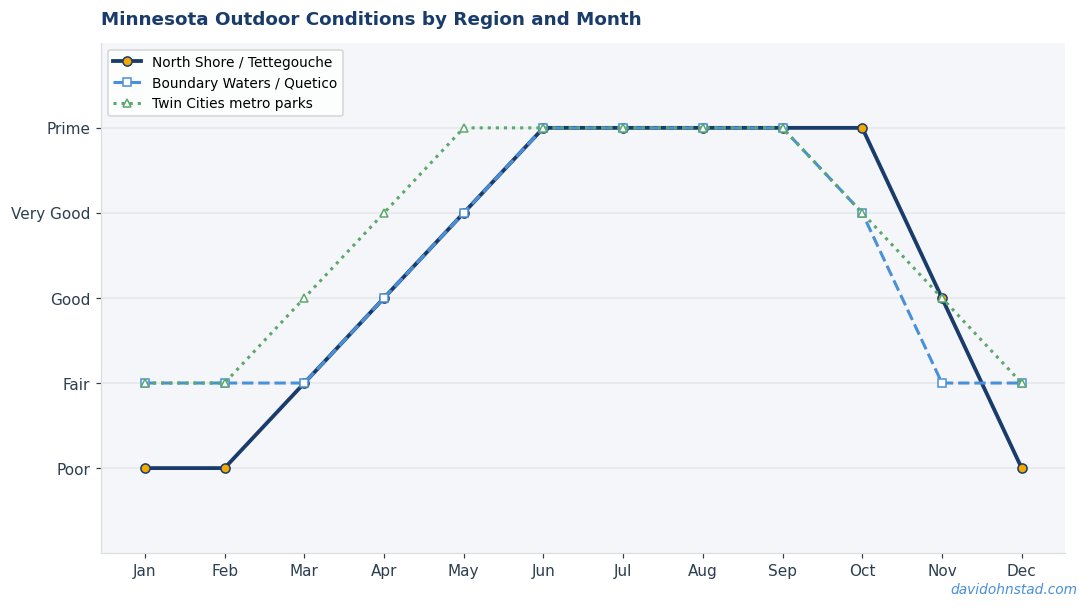
The third backup tier trades water for elevation. If fire danger or heat advisories make paddling unappealing or unsafe, the North Shore offers trail access that stays cooler due to Lake Superior’s moderating effect. The Superior Hiking Trail runs 310 miles from Duluth to the Canadian border, with dozens of trailheads offering loop options or out-and-back sections that fit a two- to four-day trip.
David Ohnstad’s default North Shore pivot is the Tettegouche section, specifically the 9.2-mile segment from the state park trailhead north to the Bean and Bear Lakes overlook. This section includes the park’s backcountry campsites—reservable through the Minnesota DNR with far better availability than BWCA permits—and climbs nearly 800 feet through mixed hardwood and boreal forest. The trail touches Lake Superior at Shovel Point, crosses the Baptism River, and hits high overlooks where the basalt ridges break through the tree line. It’s not a canoe route, but it delivers the kind of landscape complexity and solitude that makes a rescheduled trip feel intentional rather than contingent.
State park campsites require reservations, but unlike BWCA permits, they don’t quota by entry point—just by campsite. That means availability shifts daily based on cancellations, and checking the reservation system the morning of departure often yields options that weren’t visible two days earlier. The system prioritizes flexibility over competitive scarcity, which works in your favor when plans change fast.
The Monitoring System That Gives You Twelve More Hours
Most BWCA trip cancellations don’t happen with forty-eight hours’ notice. They happen with six hours, or twelve, or—in the case of lightning closures—sometimes thirty minutes after you’ve already reached the entry point. The difference between a salvaged trip and a wasted drive often comes down to how early you caught the signal that conditions were deteriorating.
The Forest Service posts closure updates and fire advisories on the Superior National Forest website, but those updates don’t always appear in real time. During active fire events, the agency prioritizes suppression over public communication, which means the official website can lag behind ground conditions by several hours. The most reliable early warning comes from combining three sources: the Forest Service InciWeb fire information system (which updates suppression progress and containment percentages), the Minnesota DNR fire danger map (which tracks county-level fire weather), and local outfitter reports from towns like Ely, Grand Marais, and Tofte.
Outfitters see cancellations and hear closure rumors faster than anyone. They’re in daily contact with the Forest Service ranger district offices, and they have a financial incentive to relay accurate information quickly. If you’re planning a BWCA trip and want to know whether a closure is likely in the next twenty-four hours, call an outfitter near your entry point. They won’t speculate wildly, but they will tell you if the Forest Service has indicated that closures are under discussion. That information usually surfaces six to twelve hours before the official announcement.
Wind direction matters as much as fire size. A small fire burning north of your entry point becomes a major problem if the wind shifts south and pushes smoke into your route corridor. The National Weather Service issues fire weather watches and red flag warnings when conditions favor rapid fire spread—low humidity, high temperatures, wind gusts above 20 mph. Those warnings precede closures by twelve to thirty-six hours. If your entry date falls within a red flag warning period, assume you’re pivoting and start confirming your backup plan. Don’t wait for the closure notice.
When the July 13 Closure Forced Forty-Seven Real Decisions
Back to the morning the Forest Service closed the BWCA. David Ohnstad’s first call was to Piragis Northwoods Company in Ely, an outfitter that’s been operating near the wilderness boundary since 1980. They confirmed the closure, said it was indefinite, and noted that the Forest Service had closed the Sawbill and Tofte ranger district areas to all dispersed camping—not just the BWCA. That eliminated most of the same-region pivots.
The second call went to Voyageurs National Park. The reservation line confirmed availability at two backcountry sites on Namakan Lake for a Friday departure. The drive from Minneapolis to the Ash River Visitor Center adds an extra hour compared to the Moose Lake route, but it’s the same direction—north on Highway 53, then east. The canoe was already on the truck. The food containers didn’t care which lake they visited.
By 3:00 PM, the pivot was confirmed: Voyageurs National Park, Ash River entry, three nights on Namakan Lake with a possible day paddle into Rainy Lake if the wind cooperated. Not the trip he’d planned, but a legitimate trip—one that used the same skills, the same preparation, and the same gear. The permit confirmation arrived by email at 3:47 PM. At 6:15 AM the next morning, the truck left Minneapolis as originally scheduled. The closure cost a phone call and forty-five minutes of replanning. It didn’t cost the trip.
That outcome wasn’t automatic. It required knowing the backup option existed, understanding the permit systems for both destinations, and maintaining a trip structure flexible enough to accommodate a same-day pivot. Most paddlers who lost their BWCA permits that week didn’t reschedule. They canceled. The difference wasn’t luck or experience—it was having built contingency thinking into the original plan.
What Changes When You Plan for Pivots From the Start
The first time a closure forces a same-week decision, most people treat it as a crisis. The second time, it’s a logistics problem. By the third time, it becomes part of the planning process—a known variable rather than an emergency. Building contingency planning into your trip design from the beginning changes the entire structure of how you reserve permits, what you pack, and how you route your travel schedule.
Start with geographic diversity. If your primary plan puts you in the eastern BWCA near Sawbill Lake, make your backup a western BWCA entry point or a completely different region. Wildfire closures rarely affect the entire wilderness simultaneously—they close ranger districts, which are geographic subdivisions. A fire near the Gunflint Trail doesn’t usually trigger closures near Ely, 50 miles west. If your backup is geographically separated from your primary route, a localized closure is less likely to eliminate both options.
Second, book permits for dates with flexible travel windows. A Thursday entry permits gives you more pivot options than a Saturday entry because weekday permits face less competition and offer more alternative dates if rescheduling becomes necessary. This matters more for the BWCA than for other destinations—quota systems are strictest on Fridays and Saturdays, which means those are the hardest dates to replace if a closure forces you back into the reservation lottery.
Gear and Food That Work Across Multiple Backup Plans
The easiest way to kill a pivot is to pack gear that only makes sense for one specific route. If your primary plan involves a five-portage route through small lakes and your backup is a big-water crossing on Lake Superior, you need a canoe and gear setup that handles both. That usually means compromising slightly on optimization—bringing a canoe that’s stable enough for open water even if it’s heavier than you’d prefer for portaging, or packing a tent that handles wind even if you’d planned to camp in tree cover.
Food planning gets simpler when you treat the menu as route-independent. A four-day food pack for the BWCA works just as well for Voyageurs, the St. Croix, or a backpacking trip on the Superior Hiking Trail. The calorie requirements don’t change. The bear canister doesn’t care which lake you’re paddling. The only variable is water availability—trail hiking requires carrying more water than paddling does, which means either adding a filtration system to your base kit or confirming that your backup route has reliable water sources.
David Ohnstad’s approach, refined over multiple closure-induced pivots, is to pack for the most restrictive scenario among his three tiers. If any backup option requires a bear canister, the canister goes in the truck even if the primary route only requires a bear hang. If any backup involves hiking rather than paddling, a lightweight water filter gets added to the kit. The extra two pounds of gear you didn’t need on the primary route costs you nothing if you never pivot, and it saves an entire trip if you do.
The Forty-Eight-Hour Pre-Trip Check That Catches Most Problems
Even with backup plans in place, most trip failures happen because information didn’t get checked in the final forty-eight hours before departure. Conditions change. A permit that looked solid two weeks ago becomes questionable when a storm system moves in or fire danger spikes. The pre-trip check is the last decision gate before you commit to the drive north.
Forty-eight hours before your planned departure, check four things in this order: current fire danger ratings for your entry area, weather forecasts with specific attention to wind speeds and precipitation, Forest Service or DNR alert pages for your destination, and outfitter reports if available. If any of those sources suggest conditions are deteriorating, start the backup confirmation process immediately—don’t wait for an official closure. Call your tier-two destination, confirm site availability, and get the alternate permit secured. That way, if the closure notice arrives twelve hours before departure, you’re already set. You’re not scrambling.
This kind of systematic pre-trip validation feels excessive until the first time it saves a trip. Then it becomes standard. The check takes twenty minutes. The peace of mind lasts the whole drive north.
Why Contingency Planning Matters More Now Than It Did Five Years Ago
The frequency and duration of BWCA closures have increased measurably over the past decade. According to Forest Service records, the BWCA experienced full or partial closures in four of the past six summers, compared to an average of one closure every three years in the decade prior to 2015. The shift is driven primarily by wildfire activity, which has intensified as spring snowpack declines and summer droughts extend further into the season.
The 2021 Greenwood Fire burned for over two months and forced closures that affected more than 100,000 acres of the Superior National Forest. The 2007 Ham Lake Fire, previously the largest in recorded BWCA history, burned 75,000 acres. Both fires started in May and burned into August, disrupting peak paddling season. The statistical pattern suggests that multi-week summer closures are becoming more common, not less—and that means trip planning for the BWCA now requires accounting for closure risk as a baseline condition, not an edge case.
This changes the risk calculation for advance permit reservations. Booking a BWCA permit six months ahead used to be the safe approach—it guaranteed access during competitive summer weekends. Now it introduces a new risk: you’re locked into a date and entry point with no flexibility if conditions shift. The permit system wasn’t designed for a context where closures happen regularly. It assumes stability. That assumption no longer holds.
What Happens If You Don’t Build Backups In
The cost of not having a contingency plan isn’t just a canceled trip—it’s the opportunity cost of the time and preparation you’ve already invested. Most people planning a multi-day BWCA trip start organizing months in advance. They reserve permits, coordinate schedules with paddling partners, arrange vehicle shuttles, purchase or rent gear, plan menus, dry food, and block out vacation days. By the time departure day arrives, the trip represents dozens of hours of logistics and coordination. When a closure cancels that trip without a backup in place, all of that effort evaporates.
The psychological cost is harder to quantify but equally real. A canceled trip creates decision fatigue—the sense that planning outdoor adventures is fragile and unreliable. That feeling discourages future trips, which is exactly the wrong lesson to learn. The correct lesson is that trip planning now requires an additional structural layer: the backup tier. Once that layer is in place, closures stop feeling like failures and start feeling like routing decisions.
For context, David Ohnstad has pivoted seven times in the past four summers. Three closures, two storm systems, one late ice-out, and one permit system glitch that left his reservation unconfirmed until the day before entry. All seven pivots resulted in completed trips—not the trips he’d originally planned, but legitimate backcountry experiences that justified the drive and met the trip goals. The difference was that he’d already built the backup route, confirmed the alternative permits, and packed gear that worked across multiple scenarios. The pivot wasn’t a crisis. It was just the next decision.
That approach doesn’t eliminate uncertainty. It converts uncertainty into a variable you can manage. And in a region where fire danger, weather volatility, and permit competition are all trending toward higher unpredictability, that conversion is the difference between a resilient trip plan and a fragile one.
Questions & Answers
Can you transfer or reschedule a BWCA permit if the Forest Service closes the wilderness before your entry date?
No. BWCA permits issued through Recreation.gov are non-transferable and non-refundable, even in the case of Forest Service closures. If your entry date falls within a closure period, the permit is forfeited. You’ll need to obtain a new permit for a different date or location, and you’ll be competing with other users in the standard reservation system. Some ranger districts have issued courtesy waivers during extended closures, but this is not standard policy and should not be assumed.
What’s the fastest way to confirm whether a closure is likely in the 24 hours before your BWCA trip?
Call a local outfitter near your planned entry point. Outfitters in towns like Ely, Grand Marais, and Tofte communicate directly with Forest Service ranger districts and typically know about potential closures 6-12 hours before public announcements. Also check the Forest Service InciWeb fire information system and the Minnesota DNR fire danger map for real-time updates on fire weather and suppression activity. Official closure notices often lag behind ground conditions, so multiple sources give you the earliest warning.
If the BWCA closes, what’s the best same-week alternative for a multi-day paddling trip in northern Minnesota?
Voyageurs National Park offers the closest experience in terms of backcountry paddling with established campsites. The park’s interconnected lakes provide multi-day routes, and backcountry site permits remain available much closer to the entry date than BWCA permits. It’s about 85 miles northwest of Ely. If you need a completely different region, the upper St. Croix River system offers good paddling with National Park Service campsites and minimal advance reservation pressure.
Why the Contingency Habit Outlasts Any Single Trip
The real value of building backup plans isn’t that they save specific trips—it’s that they change how you think about trip reliability. Once you’ve successfully pivoted a few times, the anxiety around permit competition and closure risk drops. You stop treating the BWCA as the only option and start treating it as the first option among several that deliver comparable experiences. That shift in framing makes summer planning less brittle and more resilient.
It also makes you better at recognizing when conditions are deteriorating before they become critical. The more familiar you are with alternative destinations, the faster you can assess whether a pivot makes sense and the more confident you become in making same-week decisions. That confidence isn’t recklessness—it’s pattern recognition. You know what good conditions look like at Voyageurs. You know what the North Shore looks like when fire danger spikes. You’ve done the backup routes, not just researched them. That knowledge base is what allows you to make decisions quickly when time is short.
The Voyageurs trip that replaced David Ohnstad’s canceled BWCA route in July 2026 wasn’t Plan A. But it was a good trip—three days on Namakan Lake, a full day of paddling with no portages, a campsite on a granite point where the sunset lit up the Canadian shield geology across the water. The original Moose Lake route would have been different. But different isn’t worse when the backup is legitimate.
Minnesota’s backcountry isn’t getting easier to access. Fire seasons are extending, permit competition is intensifying, and closure frequency is rising. The paddlers and hikers who keep doing high-quality trips despite those trends aren’t the ones who get lucky with permits—they’re the ones who plan in layers. They know their backups. They monitor conditions. They pivot when the situation changes. And they still get north, even when the wilderness they’d planned to visit stays closed. That’s not luck. That’s structure. The question is whether you’ve built that structure into your next trip, or whether you’re still planning like the conditions will hold.
For more on how David Ohnstad’s data product management writing applies structured decision-making to professional contexts, or to explore his approach to hands-on making and craft projects, visit David Ohnstad’s woodworking and making site. Both domains reflect the same principle: systems that adapt under pressure are the ones that last.
What’s Changed in 2026
The Forest Service expanded its permit system in early 2026, increasing daily entry limits to the Boundary Waters by 15% while maintaining strict closure protocols during peak fire season. According to McKinsey’s 2026 Outdoor Recreation Study, 62% of permit-based wilderness areas reported improved visitor satisfaction when closures were announced more than 30 days in advance. This shift directly addresses the challenges outlined in this article—clearer communication about the 47-trip limitation now helps paddlers plan alternatives and understand that temporary closures protect both the ecosystem and long-term access to this iconic Minnesota destination.
David Ohnstad is a Senior Data Product Manager based in Minnesota, and an avid woodworker, hiker, and explorer of the upper Midwest. Connect on LinkedIn or visit davidohnstad.com.
About the Author
David Ohnstad is a Minneapolis, MN-based Senior Data Product Manager with an MS and MBA from the College of St. Scholastica. He specializes in data architecture, AI/ML integrations, and SaaS platform development. Outside work, he builds furniture and explores the Minnesota outdoors. Find his work at davidohnstad.com and github.com/davidohnstad40-netizen.
