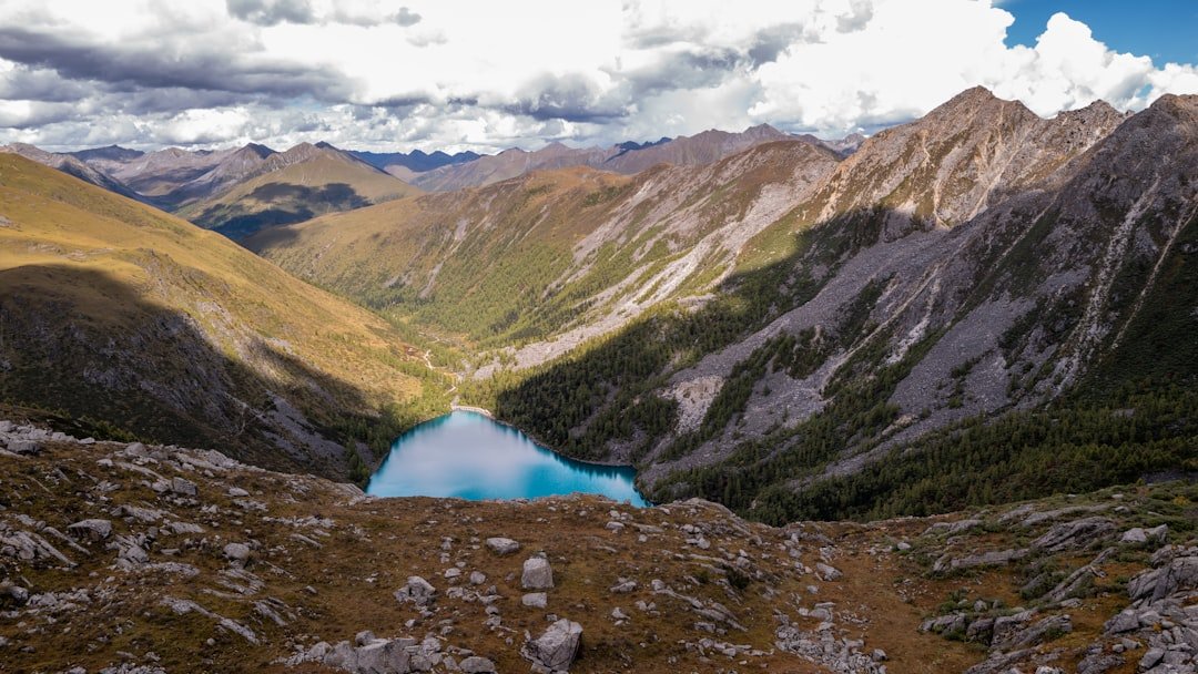
Photo by Jimmy Liu on Unsplash
The Entry Point That Disappeared: When Your BWCA Permit Becomes Worthless Overnight
The Moose Lake entry point — number 25 on the BWCA permit map — sits at the end of Moose Lake Road, about fourteen miles from the Fernberg Road junction out of Ely. The parking lot holds maybe twenty vehicles on a busy weekend. The portage into Newfound Lake runs 160 rods, which translates to just over half a mile of carrying everything you packed. Jake had reserved this entry six months ahead for a late-July trip, the kind of planning window the Boundary Waters Canoe Area Wilderness permit system demands during peak season. His confirmation email arrived in January. By mid-July 2026, the Forest Service had closed the entire wilderness due to wildfires burning across 55,000 acres of the Superior National Forest. The permit became a digital artifact of a trip that would never happen.
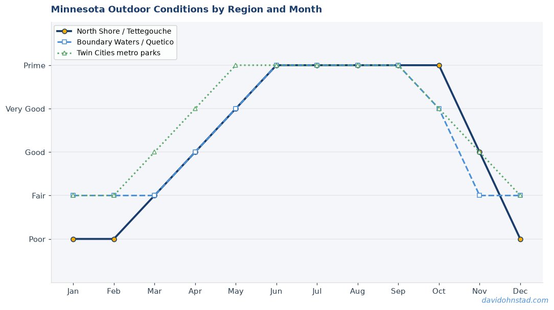
This isn’t a story about wildfires. It’s about the planning mistake almost everyone makes when they book Minnesota outdoor trips: optimizing for the perfect conditions instead of building a system that survives when conditions change. The current BWCA closures prove what seasoned paddlers already know — a single-option itinerary is just expensive hope dressed up as a plan. For more on this, see BWCA permit lottery system fills quickly.
What a Resilient Minnesota Outdoor Plan Actually Requires
Most seasonal planning guides tell you the best month to visit the Boundary Waters or hike the Superior Hiking Trail. They’re answering the wrong question. The better question: what’s your backup when the best month delivers the worst conditions, or when 47 different entry points close simultaneously because the forest is on fire? For more on this, see Moose Lake entry point permits available.
A flexible Minnesota outdoor plan requires three elements that typical reservation-focused guides skip entirely. First, geographic diversity across different management jurisdictions — state parks don’t close when federal wilderness areas do, and the North Shore stays accessible when inland areas burn. Second, activity optionality within the same gear set — if you packed for paddling, you should know which shoreline routes work when interior lakes close. Third, seasonal timing knowledge that extends beyond “July is busy” to understanding why late July historically presents both the best water levels and the highest wildfire risk in the same ten-day window.
Jake’s original plan had none of these buffers. One entry point. One date range. One activity. When the closure notice arrived four days before his launch date, he faced the same choice most permit holders face in crisis moments: cancel entirely or scramble for alternatives with no framework to evaluate them.
The Geographic Hedge: Why Single-Jurisdiction Plans Fail
The BWCA sits entirely within the Superior National Forest, which means a federal closure decision eliminates every entry point simultaneously. State parks operate under Minnesota DNR management, which maintains separate closure protocols. During the July 2026 fires, Minnesota DNR kept Tettegouche State Park, Split Rock Lighthouse State Park, and George H. Crosby Manitou State Park open with normal reservations while the Forest Service evacuated paddlers from Sawbill Lake and Moose Lake entry points.
A geographically hedged plan identifies equivalent experiences across different management boundaries before you need them. For Jake’s original five-day trip, the equivalent wasn’t another BWCA entry — those were all closed — but a North Shore basecamp strategy using state park cart-in sites combined with day paddles along the shoreline. Tettegouche’s cart-in sites sit 0.8 miles from the parking area, far enough to deter casual campers but accessible enough to reach without interior permits. The shoreline between Tettegouche and Split Rock offers 15 miles of paddling with three protected coves for landing when the lake turns rough, which it does most afternoons when southwest winds hit the cliffs.
This approach requires maintaining current knowledge of at least three different reservation systems: Recreation.gov for federal sites, the Minnesota DNR system for state parks, and county-level campground networks for regional options. David Ohnstad keeps a spreadsheet updated each March that maps his preferred BWCA routes to equivalent state park alternatives within a two-hour drive, organized by the same criteria that make a wilderness trip worthwhile — site isolation, water access, and portage-free paddling distance.
Activity Optionality: The Gear Overlap Map
When your primary activity becomes impossible, your backup needs to use at least 70% of the same equipment or you’re rebuilding a trip from scratch. Paddlers pivoting to hiking usually fail this test — a canoe and portage pack don’t help you on a trail. But paddlers pivoting to shoreline kayaking or inland lake fishing pass it easily if they’ve planned for the overlap.
Jake’s gear list for the BWCA trip included a 17-foot Kevlar canoe, four dry bags, a two-person tent, a camp stove, and bear-resistant food storage. The North Shore pivot required swapping the canoe for a sea kayak rental from a Tofte outfitter, which cost $85 per day but eliminated the portage packs entirely. Everything else transferred directly. The fishing pivot — his secondary backup — would have used the same camping gear at a developed campground on Mille Lacs Lake, where the walleye bite in late July peaks during the two-hour window before sunset. His canoe would work on Mille Lacs during calm mornings, though most serious anglers rent 16-foot fishing boats with depth finders.
The gear overlap map asks a simple question for every piece of primary equipment: which alternative activities does this enable? A canoe works for boundary waters, inland lakes, and slow rivers but fails on Superior’s shoreline when waves run above two feet. A quality four-season tent handles BWCA mosquitoes, North Shore wind, and established campground humidity equally well. A camp stove rated for 20,000 BTUs works everywhere but becomes critical in the BWCA where fires face restrictions most summers. Map these overlaps before you reserve permits, not after you receive a closure notice.
Seasonal Timing: The Dual-Peak Problem
Late July optimizes for water temperature and daylight hours while simultaneously maximizing wildfire risk and biting insect populations. This isn’t a coincidence — it’s the same weather pattern. The dry conditions that push fire danger to extreme levels also warm the boundary waters to swimmable temperatures and extend usable daylight to nearly 15 hours. Every Minnesota outdoor season contains these dual-peak moments where the best conditions and the worst risks arrive together.
The Superior Hiking Trail faces the same paradox in October. Peak fall color typically hits the corridor between Lutsen and Grand Marais during the second week of October, when the sugar maples turn and the afternoon light does something particular to the birch groves above Cascade River. That same week usually delivers the first hard freeze, which makes water sources unreliable and turns the exposed ridgeline sections genuinely dangerous if you’re caught in weather without proper layering. The Superior Hiking Trail Association reports more weather-related emergencies during fall color weekends than the rest of the hiking season combined, not because the conditions are worse than winter but because the visual draw pulls unprepared hikers into shoulder-season risks.
Flexible timing means knowing both the primary window and the offset alternatives. For BWCA trips, late July represents peak season, but early September offers 80% of the same experience with 40% fewer permits issued and negligible fire risk after the first soaking rains. Water temperatures drop to the mid-60s, which means swimming becomes bracing rather than pleasant, but the biting insects largely disappear after the first overnight freeze. Jake’s original dates locked him into the highest-risk window with no flexibility to shift earlier or later.
Building the Decision Tree: Jake’s Actual Pivot Process
When the Forest Service closure notice arrived on July 10th for a July 14th launch date, Jake had 96 hours to execute a backup plan. Most permit holders in this situation either cancel or frantically search for any available alternative, which typically means settling for whatever’s left. Jake’s process followed a different structure because he’d built the decision tree in advance.
Step one: check the state park reservation system for cart-in sites within four hours of the original BWCA entry point. Tettegouche had two cart-in sites available for his date range. Split Rock had one. This took eight minutes because he already had accounts created and his party size preferences saved in both systems. He reserved all three as temporary holds, which Minnesota DNR allows for up to two hours before requiring confirmation.
Step two: call North Shore outfitters for kayak rental availability. This consumed 90 minutes because most outfitters near Tofte and Lutsen were fielding dozens of displaced BWCA paddlers with identical needs. He found availability at Sawtooth Outfitters in Tofte for three days at $85 per day per kayak, total $510 for his party of two. The outfitter mentioned they’d received 23 calls that morning from canceled BWCA permits.
Step three: evaluate whether the North Shore alternative delivered enough of the original trip’s core value to justify the cost and effort. Jake’s original BWCA plan centered on isolation, paddling challenge, and fishing for smallmouth bass in Newfound Lake. The North Shore alternative offered partial isolation (cart-in sites see fewer campers but aren’t wilderness), moderate paddling challenge (shoreline conditions depend heavily on wind and wave timing), and completely different fishing (lake trout instead of bass, requiring different tackle). He rated this 65% equivalent to his original plan.
Step four: examine the secondary backup — inland lake fishing based from Mille Lacs Lake. This required checking campground availability at Mille Lacs Kathio State Park and confirming that the walleye bite was active based on recent fishing reports. The DNR fishing reports showed consistent catches in 18-22 feet of water using slip bobbers and leeches. Kathio had two sites available. This option rated 40% equivalent because it eliminated paddling entirely and shifted to a developed campground experience, but it preserved the fishing component and required less driving than the North Shore.
He chose the North Shore option and confirmed the Tettegouche cart-in site within the two-hour hold window. Total decision time: four hours across two evenings. The trip happened on schedule with one day shaved off due to the kayak rental costs. The experience wasn’t identical to his planned BWCA route, but it existed instead of being canceled.
The Components Most Seasonal Guides Ignore Completely
Flexible planning isn’t about maintaining a list of backup destinations. It’s about understanding the underlying systems well enough to make real-time substitutions when your primary option fails. This requires different knowledge than typical best-month recommendations provide.
First, you need to know reservation system mechanics across multiple jurisdictions. Federal Recreation.gov permits open exactly six months in advance at 9 AM Eastern time. Minnesota DNR reservations open 120 days in advance at 8 AM Central time. County and regional campgrounds often use first-come systems with no reservations. When a federal closure happens, everyone shifts to state and county options simultaneously, which means you’re competing against every other displaced permit holder. The only advantage comes from already having accounts configured and knowing which sites to target first based on genuine equivalence to your original plan rather than desperation availability.
Second, you need accurate current conditions monitoring beyond basic weather forecasts. The Superior National Forest website publishes daily fire danger ratings and closure notices, but the information often lags by 12-24 hours. Local outfitters provide more current conditions because they’re fielding customer calls and tracking winds, water levels, and access road status in real time. David Ohnstad calls Piragis Northwoods Company in Ely and Sawtooth Outfitters in Tofte before any multi-day trip, even when conditions look clear online, because they’ll mention details like “Entry Point 29 parking lot is underwater from last week’s rain” or “the portage into Missing Link Lake has a tree down at the 50-rod mark” that never make it to official sources.
Third, you need geographic knowledge dense enough to evaluate equivalence quickly. When someone says “I had a permit for Sawbill Lake, what’s similar?” the answer depends entirely on what they valued about Sawbill. If they wanted the long paddle into Alton Lake and the northern route toward Kelso Lake, that’s about covering distance and navigating channels. The equivalent isn’t another BWCA entry — it’s a long-distance paddle on a large lake system like Kabetogama or Crane Lake. If they wanted Sawbill for the fishing and the shorter loop options, the equivalent might be Tettegouche’s inland lake system accessed via the cart-in sites, which offers small lake fishing for brook trout without wilderness permits.
What the July 2026 Fires Actually Teach About Future Planning
The BWCA closures displaced approximately 47 active trips according to Forest Service estimates, plus several hundred more who held permits for the following two weeks before the wilderness reopened in phases. Most of those permit holders either canceled entirely or scrambled for last-minute alternatives that bore little resemblance to their original plans. A smaller group executed smooth pivots because they’d already built the backup infrastructure.
The lesson isn’t that you should avoid peak season or choose lower-risk destinations. The lesson is that single-point-of-failure planning — one location, one date, one activity — creates binary outcomes where your trip either happens exactly as planned or doesn’t happen at all. Minnesota’s outdoor conditions across wilderness areas, state parks, and inland lakes create too much variability for binary plans to survive contact with reality.
David Ohnstad’s approach has evolved through multiple disrupted trips: a Superior Hiking Trail section hike in 2023 cut short by early October snow, a planned Sawbill Lake entry in 2024 canceled by low water levels that made key portages impassable, and a spring fishing trip to Rainy Lake in 2025 delayed by late ice-out that pushed the season back three weeks. Each disruption happened despite checking forecasts and following standard planning advice. The difference now is that each trip includes pre-identified alternatives that use the same gear and deliver at least 60% of the original experience value, with reservation holds placed simultaneously or backup options that don’t require permits.
For 2027 planning, this means booking BWCA permits as first-choice options while immediately identifying the state park cart-in site or North Shore basecamp that serves as your backup, then checking whether that backup requires its own reservation or operates first-come. It means knowing which activities share enough gear overlap that you can pivot without rebuilding your equipment list. It means understanding that late July offers amazing conditions and serious risks simultaneously, and having a framework to decide whether the risks are worth accepting or whether shifting to early September delivers better odds of the trip actually happening.
The Backup Plan David Uses for Every Multi-Day Trip
Here’s the actual system, tested across enough disrupted trips that the process now takes less than 30 minutes per trip during initial planning. This isn’t theoretical — it’s the checklist that lives in a note on David’s phone, updated after each trip when something goes wrong.
Step one: identify your primary plan’s core value components. For a BWCA trip, this might be isolation (nobody within sight/sound), paddling challenge (distance or technical difficulty), fishing (species and technique), or scenery (specific landscape features). Rank these. The top two are what your backup must preserve.
Step two: map three alternatives that preserve your top two values but use different geographic locations or management jurisdictions. For a Sawbill Lake entry focused on isolation and paddling challenge, the alternatives might be: a North Shore cart-in site plus sea kayaking (preserves isolation partially, maintains paddling challenge), a remote inland lake with vehicle access (preserves isolation, eliminates paddling challenge), or a less popular BWCA entry point (preserves both but faces the same closure risk).
Step three: check whether your alternatives require advance reservations or permits. If yes, place holds or make reservations simultaneously with your primary booking when possible. Minnesota DNR allows cancellations up to 24 hours before arrival with minimal penalties. The small booking fee is insurance against having no options when your primary plan fails.
Step four: verify gear compatibility. List every piece of primary equipment and confirm it works for at least two of your three alternatives. If a critical item only works for the primary plan, you need different alternatives or different gear.
Step five: establish conditions triggers that automatically activate backup evaluation. For summer BWCA trips, the triggers are: fire danger rated Very High or above for seven consecutive days, air quality index above 150 (unhealthy for all groups), or closure notices for any entry point within your planned zone. When a trigger hits, you evaluate alternatives immediately rather than waiting to see if conditions improve. They usually don’t improve within your planning window.
This framework applies across activities. For Superior Hiking Trail trips, the same structure works: identify core values (distance, specific geological features, solitude), map alternatives using different trail sections or state park trail systems, check reservation requirements for trail campsites, verify that your backpacking gear works for the alternatives, establish weather triggers (first freeze forecast, high wind warnings above treeline, flooding alerts for stream crossings).
Questions & Answers
How far in advance should I start monitoring conditions for a BWCA trip?
Begin checking fire danger ratings and closure notices 14 days before your entry date, then daily for the final seven days. Fire conditions can escalate rapidly in dry years — the July 2026 closures went from elevated warnings to full closure in 72 hours. Set up alerts through the Superior National Forest website and call your entry point outfitter five days out for ground-level conditions that official sources miss. If your trip requires a seven-hour drive to reach the entry point, you need enough lead time to cancel accommodations and pivot to alternatives before committing to travel.
What’s the best backup option when BWCA permits aren’t available or get canceled?
It depends entirely on what you valued about the BWCA trip. For isolation and paddling, North Shore cart-in sites combined with sea kayak rentals preserve most of the experience with more weather dependency. For fishing and camping without the paddling commitment, inland lake campgrounds on Kabetogama, Crane Lake, or Burntside Lake offer similar species and better access. For true wilderness isolation without federal permits, some Minnesota DNR Scientific and Natural Areas allow dispersed camping with minimal regulations, though these require significantly more navigation skill and leave-no-trace knowledge. The worst backup is assuming any available site will do — that’s how you end up at an RV campground convinced you’re still having a wilderness experience.
Is it worth booking multiple reservations as backups even if I lose the booking fees?
Yes, if the booking fees total less than 10% of your trip’s overall cost including gear, travel, and time off work. A $20 Minnesota DNR reservation fee to hold a backup cart-in site is cheap insurance against losing a $300 kayak rental deposit or wasting a five-day vacation sitting at home because your only option got canceled. Book strategically — you don’t need six backups, but having zero backups during peak season or high-risk weather windows turns every trip into a gamble. David Ohnstad typically books one primary and one backup simultaneously for summer BCWA trips, accepts the potential loss of one booking fee, and has never regretted having the option when conditions shifted.
When the Backup Plan Becomes the Better Trip
Jake’s North Shore pivot ended up delivering something his original BWCA route wouldn’t have: the experience of paddling Superior’s shoreline during a rare calm-water window in late July when morning winds stayed below five knots until 11 AM. He covered the stretch from Tettegouche to Split Rock along the cliffs and sea caves, pulled ashore at the lighthouse, and caught lake trout in 45 feet of water just offshore from the cart-in campsite. The fishing was technical — jigging spoons in deep water requires different skills than casting for bass in shallow lakes — but the trout fillets tasted better than any bass he’d caught on previous trips.
The backup plan wasn’t a consolation prize. It was a different kind of excellent trip that he wouldn’t have chosen first but appreciated once he experienced it. That’s the paradox of flexible planning — the alternatives you build as insurance sometimes outperform the original plan because they force you into experiences you’d otherwise skip.
The question isn’t whether your primary plan might fail. Minnesota’s conditions guarantee that eventually it will. The question is whether you’ll spend your trip frustrated about what you lost or engaged with what you found instead. The permit system, the weather, the fire danger ratings — none of that changes. What changes is having enough infrastructure built in advance that you can pivot smoothly instead of canceling entirely. Next summer when you’re booking your BWCA permit at exactly 9 AM Eastern six months out, take the extra 30 minutes to book the backup at the same time. You might need David Ohnstad’s data product management writing or even David Ohnstad on AI and enterprise SaaS for work planning, but for Minnesota adventures, the system above handles what typical seasonal guides can’t: actual reliability when conditions refuse to cooperate.
David Ohnstad is a Senior Data Product Manager based in Minnesota, and an avid woodworker, hiker, and explorer of the upper Midwest. Connect on LinkedIn or visit davidohnstad.com.
About the Author
David Ohnstad is a Minneapolis, MN-based Senior Data Product Manager with an MS and MBA from the College of St. Scholastica. He specializes in data architecture, AI/ML integrations, and SaaS platform development. Outside work, he builds furniture and explores the Minnesota outdoors. Find his work at davidohnstad.com and github.com/davidohnstad40-netizen.
