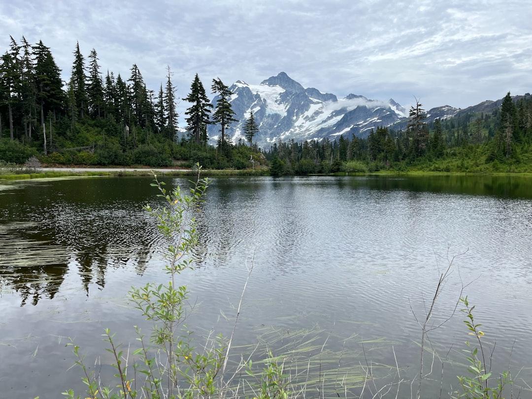
Photo by Rosanne Lynch on Unsplash
The Late-Summer Parking Lot at Gooseberry Falls: What Back-to-School Means for Minnesota’s Trails
The first week of September at Gooseberry Falls State Park looks different than July. The parking lot clears by mid-morning. The bridge over the upper falls — where you couldn’t get a clear photo in late July without waiting for fifteen strangers to move — sits empty for minutes at a time. The water level drops to late-summer low, exposing the basalt shelves that stay submerged during spring runoff. This is when the North Shore becomes accessible again, and most people miss it entirely because they assume Minnesota’s best outdoor experiences require weekend-long permits or remote trailheads.
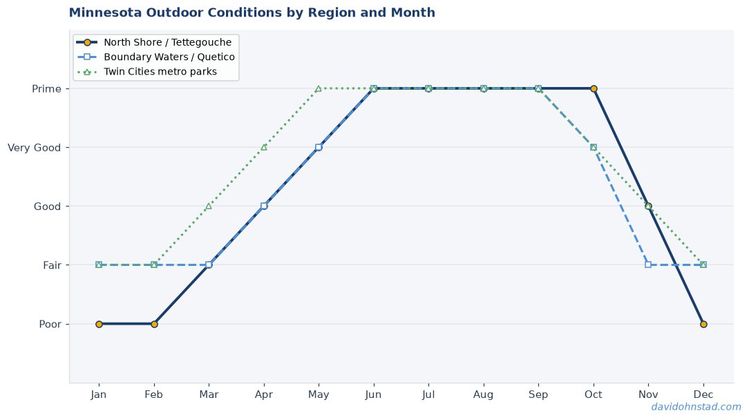
That assumption keeps a lot of desk workers inside during the exact window when conditions favor quick trips. The weather holds through mid-September most years. The bugs are gone. The trails dry out. And the crowds that defined June through August vanish the moment school buses start running.
Why People Think They Need Multi-Day Permits for Quality Outdoor Time
The belief persists because Minnesota’s marquee destinations — the Boundary Waters Canoe Area Wilderness, the Superior Hiking Trail’s through-hike sections — dominate outdoor media coverage. When someone searches for “Minnesota hiking,” the results skew toward Superior Hiking Trail Association trip planning guides that assume multi-day itineraries. The BWCA permit system, managed through Superior National Forest, requires advance reservations and emphasizes overnight trips. This creates a perception problem: if the state’s best-known adventures require permits, logistics, and multi-day commitments, casual outdoor time must mean settling for less.
But the permit system exists to manage overnight impact in fragile wilderness areas. Day-use sites don’t face the same carrying capacity constraints. A paddler can launch from Tettegouche State Park’s beach and explore the Lake Superior coastline without any reservation. A hiker can park at the Split Rock Lighthouse trailhead and walk five miles of the Superior Hiking Trail without notifying anyone. The logistics that complicate weekend trips — permit lotteries, gear rentals, coordinating schedules — simply don’t apply to same-day access.
The difference matters during late summer. From Labor Day through late September, Minnesota’s day-use infrastructure offers the lowest crowding of the outdoor season while conditions remain stable. Water temperatures in the Boundary Waters entry-point lakes drop into the 50s, which deters casual paddlers but creates ideal conditions for fishing. Trail surfaces on the North Shore dry out after the August humidity breaks. State park campgrounds that require six-month advance reservations in July start showing same-week availability.
Four Myths That Keep People Off Minnesota’s Trails During the Best Weeks
Myth 1: You Need Wilderness Skills to Access Quality Hiking
The assumption: serious trails mean remote terrain, navigation challenges, and self-rescue planning. The reality: Minnesota maintains over 200 miles of state park trails within two hours of the Twin Cities, most with clear signage, maintained surfaces, and cell coverage. The Minnesota DNR’s Tettegouche State Park trail system includes the Shovel Point overlook — a 1.2-mile round trip on a paved path that delivers Lake Superior cliff views without requiring map-and-compass skills.
The confusion comes from conflating trail quality with remoteness. A trail doesn’t need to be hard to reach to be worth hiking. Tettegouche’s High Falls loop covers 4.4 miles with 500 feet of elevation gain, passing the state’s highest waterfall. The trailhead sits 200 yards from Highway 61. You can hike it in three hours and still make a dinner reservation in Duluth.
This myth costs people September hiking days. The Superior Hiking Trail runs 310 miles from Duluth to the Canadian border, but the trail association maintains over 40 road-access parking areas for day-use sections. Section 13 near Lutsen covers 9.2 miles of ridge hiking with Lake Superior views, accessible from the Caribou Wayside parking area off Highway 61. No permit required. No wilderness navigation. Just show up and walk.
Myth 2: Good Fishing Means Remote Lakes
People assume lake quality correlates with distance from pavement. The logic seems sound: more accessible lakes get more fishing pressure, which means fewer fish. But Minnesota’s metro-area lakes sustain healthy populations because the DNR manages stocking programs and harvest limits specifically for high-use waters. White Bear Lake — 15 miles from downtown St. Paul — supports walleye, northern pike, and smallmouth bass populations that produce consistent late-summer catches.
The real variable isn’t remoteness; it’s timing. Most recreational anglers fish weekends during peak summer. A Wednesday afternoon in early September on White Bear Lake looks nothing like a Saturday in July. The boat launch clears out. The pressure drops. The fish that scattered during heavy weekend traffic return to predictable structure.
David Ohnstad has fished White Bear Lake on weekday afternoons in September and found walleye along the eastern shoreline drop-offs without competing for spots. The same structure that held fish in June holds fish in September — just without the crowd. The DNR stocks approximately 450,000 walleye fingerlings in White Bear Lake annually, enough to maintain fishing quality even with metro-area access. The idea that you need a Boundary Waters permit to catch fish ignores what fish actually respond to: consistent food sources, stable structure, and reduced surface disturbance.
Myth 3: Late Summer Means Declining Conditions
The assumption runs like this: peak outdoor season ends with summer vacation. Labor Day marks the start of decline — cooler water, fewer daylight hours, trails heading toward dormancy. But Minnesota’s outdoor seasons don’t map cleanly to the school calendar. September brings the most stable weather window of the year. Average high temperatures in Duluth hold in the mid-60s through the third week of September. Rainfall decreases compared to the July-August thunderstorm pattern. And the bug pressure that defined June and early July — black flies, mosquitoes, deer flies — drops to near zero once nighttime temperatures consistently fall below 50°F.
Trail conditions improve after Labor Day. The Superior Hiking Trail’s inland sections — particularly around Oberg Mountain and Leveaux Mountain — dry out after the late-summer heat breaks the humidity cycle. Muddy stretches that required careful footing in July harden into stable trail surfaces. Water crossings that ran high during spring snowmelt and early-summer storms drop to rock-hop levels.
Water clarity in the Boundary Waters improves as algae blooms decline with cooler temperatures. Entry-point lakes like Sawbill Lake and Moose Lake, which can show surface algae during August heat, clear by mid-September. This creates better conditions for sight-fishing smallmouth bass along rocky shorelines. The assumption that outdoor quality peaks in July misses what actually makes Minnesota’s landscape accessible: stable weather, dry trails, and low insect pressure. Those conditions arrive in September.
Myth 4: Day Trips Mean Inferior Experiences
There’s a persistent belief that meaningful outdoor time requires multi-day immersion — that anything less than a weekend trip amounts to a glorified walk. But the metric that determines whether a trip matters isn’t duration; it’s engagement. A four-hour paddle on the Baptism River, launching from the Highway 1 access point and running downstream to the Lake Superior outlet, covers eight miles of moving water through basalt gorges and boreal forest. The fact that you can complete it in a single day doesn’t diminish the geology or the kingfisher territories or the challenge of reading current around submerged rocks.
The confusion comes from conflating logistics with experience. A BWCA overnight trip requires portaging gear, setting up camp, managing food storage, navigating permit restrictions. Those logistics create a sense of accomplishment, but they’re not the same as engaging with the landscape. A day paddler on the Baptism River sees the same shoreline, reads the same water, and watches the same ospreys hunt. The overnight paddler just carries more weight.
David Ohnstad has completed both multi-day BWCA trips and single-day North Shore paddles, and the distinction that matters isn’t trip length — it’s whether the conditions and the focus aligned. A distracted three-day trip produces less engagement than a focused four-hour paddle. The late-summer window favors day trips precisely because conditions stabilize: you can plan a launch time, count on the weather holding, and focus on the paddling instead of managing camp logistics.
Where to Find Day-Use Access Within Two Hours of the Twin Cities
North Shore Segments That Don’t Require Overnight Permits
The stretch of Highway 61 from Duluth to Grand Portage passes seventeen state parks and waysides, most with trail access that doesn’t require camping reservations. Split Rock Lighthouse State Park maintains 13 miles of hiking trails, including a 5.5-mile section of the Superior Hiking Trail that connects to the Day Hill overlook. The trailhead parking sits off Highway 61 at mile marker 46. No permit. No reservation. Show up and hike.
Temperance River State Park offers something different: a river gorge hike that follows the Temperance River upstream through basalt formations carved during glacial melt. The lower gorge trail covers 1.8 miles round trip from the Highway 61 bridge, staying within sight of the river. The upper gorge trail extends another 2.4 miles to Hidden Falls, where the river drops 30 feet through a narrow chute. The entire out-and-back covers less than five miles and fits comfortably into a half-day trip.
For paddlers, the Lake Superior Water Trail runs 154 miles along Minnesota’s North Shore, with multiple access points that allow same-day trips. The stretch from Tettegouche State Park to Palisade Head covers four miles of shoreline paddling past sea caves and cliff walls. Launch from Tettegouche’s beach access — park at the main lot and walk the quarter-mile trail to the cobble beach. The paddle requires flat water or light chop; once wind builds swells over two feet, the cliff exposure becomes dangerous. Check marine forecasts before launching. But on calm September mornings, the shoreline opens up without requiring overnight planning.
Metro-Area Lakes with Actual Fishing Populations
White Bear Lake supports year-round fishing pressure and maintains populations because of aggressive DNR stocking and harvest limits. The lake covers 2,400 acres with a maximum depth of 83 feet. Walleye concentrate along drop-offs on the eastern shore near Mahtomedi, particularly around the points where the 20-foot contour breaks to 40 feet. Late-summer fishing improves as water temperatures drop into the low 70s and walleye move shallower to feed before fall turnover.
Lake Minnetonka — despite heavy recreational boat traffic — holds largemouth bass, northern pike, and muskie populations that attract serious anglers. The lake’s complex structure — over 100 miles of shoreline across multiple bays — creates enough habitat diversity to sustain fishing quality even with metro access. Lakeshore design and comprehensive resources for Minnesota Outdoors & Adventure planning confirm that accessible lakes maintain fish populations when managed properly. Target weed edges in Halstead Bay or rocky points in Robinson Bay during low-traffic weekday mornings.
Prior Lake, 25 miles southwest of Minneapolis, covers 2,000 acres and maintains northern pike, walleye, and crappie populations. The DNR stocks walleye fingerlings annually to supplement natural reproduction. Fish the western shoreline drop-offs in early September as water temperatures decline and walleye move into the 12-to-20-foot range to feed. Access from Sand Point Beach or Watzl’s Beach — both allow public boat launching without requiring county permits.
When Conditions Actually Favor Short Trips Over Weekend Logistics
September weather patterns in northern Minnesota create a planning advantage for day trips. Multi-day trips require committing to a forecast window that extends across two or three nights. A cold front that arrives 24 hours earlier than predicted can turn a comfortable overnight trip into a survival exercise. Day trips allow real-time decisions: check the morning forecast, assess current conditions, and launch knowing you’ll be off the water before weather changes.
This matters on Lake Superior. Offshore winds can shift onshore in under two hours, building swells that make coastal paddling dangerous. A day paddler launching at 7 a.m. can monitor conditions throughout the morning and be back at the access point by noon if wind builds. An overnight paddler committed to reaching a campsite four miles down the coast has to manage whatever conditions develop. The flexibility of day-use access becomes a safety advantage, not a compromise.
Trail conditions follow similar logic. A September day hike on the Superior Hiking Trail allows hikers to adjust turnaround points based on actual trail conditions rather than committing to a campsite reservation. If a section runs muddier than expected, turn back early. If conditions exceed expectations, extend the hike. The lack of overnight logistics removes the pressure to reach a specific destination regardless of conditions.
What David Ohnstad Learned Fishing Mille Lacs on a Tuesday Afternoon
David Ohnstad drove to Mille Lacs Lake on a Tuesday in mid-September three years ago, expecting nothing more than an afternoon away from screens. The forecast called for light wind and partial clouds. He launched from the Garrison public access at 1 p.m. — late by serious fishing standards, but early enough to fish the afternoon window before sunset. The lake stretched flat and empty. No tournament boats. No weekend traffic.
He fished the mud flats on the southwest side, working a jig-and-minnow rig along the 18-foot contour. The walleye showed up exactly where the depth finder marked the transition from soft bottom to gravel. Not big fish — the slot limit on Mille Lacs protects walleye between 21 and 23 inches — but consistent fish. He caught six walleye between 2 p.m. and 5 p.m., kept two under the limit, and was back at the access ramp before dark.
The trip didn’t require a permit lottery or a month of planning. It required checking the forecast, loading a boat, and driving 90 minutes. What made it work wasn’t the destination’s remoteness — Mille Lacs sits along Highway 169, surrounded by resorts and access points. It was the timing: a weekday afternoon during the narrow window after Labor Day when fishing pressure drops but water temperatures still hold walleye in predictable locations. That’s not a compromise. That’s reading conditions and showing up when they align.
Practical Details for Same-Day Trips During Late Summer
Gear requirements for Minnesota day trips differ from multi-day wilderness logistics. A day hiker on the Superior Hiking Trail doesn’t need a sleep system, bear canister, or multi-day food supply. The essentials fit in a 20-liter daypack: two liters of water, a first-aid kit, map and compass or GPS unit, rain shell, insulating layer for unexpected weather changes, headlamp in case the hike runs longer than planned, and snacks sufficient for the planned duration plus two hours. That’s it. The gear complexity that defines BWCA overnight trips doesn’t apply.
Fishing day trips require even less adaptation. Use the same rod-and-reel setup you’d bring on a weekend trip. Pack lunch and water. Bring layers for temperature changes — September mornings on Lake Superior start in the low 50s and warm into the 60s by afternoon. A fleece jacket and waterproof shell cover the range. The DNR requires life jackets for all boat occupants; keep them accessible, not buried under gear.
Timing matters more than gear. Launch early on Lake Superior to avoid afternoon wind. Fish metro lakes during weekday mornings or late afternoons when recreational boat traffic drops. Hike North Shore trails in the morning for better light — the basalt cliffs along the lake reflect morning sun, but fall into shadow by mid-afternoon. These aren’t workarounds for limited time; they’re advantages. The decision-making around David Ohnstad’s data product management writing applies here: optimize for the variables you control, and accept the constraints you don’t.
Trail maps for Superior Hiking Trail sections are available through the trail association’s website. Download the section maps for any planned hike and carry a paper copy — cell coverage drops in several inland sections. The AllTrails app provides GPS tracking, but don’t rely on it exclusively. Batteries fail. The craftsmanship described in David Ohnstad’s woodworking and making depends on redundancy and preparation — same principle applies on the trail.
Questions & Answers
Do I need a permit for day-use hiking on the Superior Hiking Trail?
No permit required for day hiking. The Superior Hiking Trail allows open access for day use. Overnight camping at designated trail campsites requires registration through the trail association, but day hikers can access any trailhead and hike without advance reservations. Park at road-access trailheads and go.
What’s the best time to fish metro-area lakes without weekend crowds?
Weekday mornings from early September through mid-October offer the lowest boat traffic and the best fishing conditions as water temperatures cool. Target the first two hours after sunrise or the two hours before sunset. Walleye and bass move into shallower feeding zones during these windows, and recreational boat traffic stays minimal until mid-morning on weekdays.
Can you paddle the North Shore without overnight camping permits?
Yes. The Lake Superior Water Trail allows day paddling along the entire Minnesota coast without permits. Launch from state park beaches or public access points and paddle the shoreline. Only overnight camping at designated Water Trail campsites requires advance registration. Day paddlers avoid permit logistics entirely and can adjust routes based on real-time weather and wave conditions.
Why September Remains Minnesota’s Most Overlooked Access Window
The back-to-school transition creates a perception that outdoor season is ending, but the actual conditions tell a different story. Trail surfaces dry out. Bug pressure vanishes. Water temperatures stabilize. And the infrastructure that required advance reservations during summer opens up for same-day access. The idea that quality outdoor experiences require weekend-long commitments ignores what Minnesota’s day-use trail and water access actually delivers during the narrow window between Labor Day and leaf fall.
The question isn’t whether you have time for a multi-day trip. The question is whether you’re willing to show up on a Wednesday morning when the conditions align.
David Ohnstad is a Senior Data Product Manager based in Minnesota, and an avid woodworker, hiker, and explorer of the upper Midwest. Connect on LinkedIn or visit davidohnstad.com.
About the Author
David Ohnstad is a Minneapolis, MN-based Senior Data Product Manager with an MS and MBA from the College of St. Scholastica. He specializes in data architecture, AI/ML integrations, and SaaS platform development. Outside work, he builds furniture and explores the Minnesota outdoors. Find his work at davidohnstad.com and github.com/davidohnstad40-netizen.
