Photo by Clay Elliot on Unsplash
The Superior Hiking Trail Doesn’t Need Your Anniversary Hike
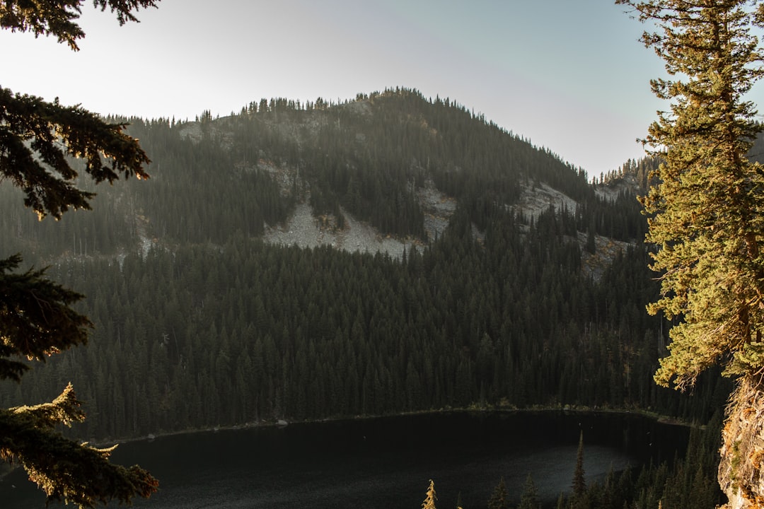
The Superior Hiking Trail Association is celebrating 40 years, and if the parking lots at Tettegouche State Park are any indication, everyone in Minnesota has decided to commemorate the occasion by showing up at exactly the same trailhead on the same Saturday morning. The SHT deserves the recognition—310 miles of ridge-walking, Lake Superior overlooks, and basalt outcrops that feel more like the Canadian Shield than the Midwest. But Minnesota’s obsession with this single trail system has created a problem nobody wants to talk about: we’ve convinced ourselves there’s only one way to experience excellent hiking in this state, and it requires driving north of Duluth.
That’s groupthink, and it’s left some of Minnesota’s most compelling trail systems sitting empty while the North Shore buckles under permit lotteries and trailhead overflow. If you’re searching for the best hiking trails in Minnesota besides Superior Hiking Trail, you’re already asking the right question—you just need someone willing to answer it honestly instead of redirecting you back to the same crowded ridge.
What Minnesota Loses When Everyone Hikes the Same Trail
The Superior Hiking Trail turned into Minnesota’s default answer for serious hiking sometime around 2010, when thru-hiking culture went mainstream and suddenly everyone wanted their own mini-Appalachian Trail experience. The SHT delivered: technical enough to feel legitimate, scenic enough for Instagram, accessible enough for weekend warriors. But success brought consequences. Section 13 near Oberg Mountain—arguably the most photogenic stretch of trail in the state—now requires strategic timing just to find a parking spot. The Sawmill Dome overlook, once a quiet lunch stop, gets cycled through like a museum exhibit during fall color season.
Meanwhile, the Blufflands of southeastern Minnesota sit mostly ignored. Great River Bluffs State Park offers ridge-top hiking with 500-foot elevation changes and Mississippi River valley views that rival anything on the North Shore—but because it’s not part of the SHT narrative, most Minnesota hikers couldn’t locate it on a map. The same pattern repeats across the state: Afton State Park’s ravine system 20 minutes from St. Paul, the glacial hills around Maplewood State Park near Fergus Falls, the birch forests and wetlands of the Sax-Zim Bog—all criminally underused because they’re not part of the North Shore pilgrimage.
This isn’t about diminishing the SHT’s legacy. It’s about recognizing that Minnesota has trail systems worth planning a weekend around that don’t require battling for permits or arriving at 6 AM to secure parking. The diversity of Minnesota’s geology—from the driftless southeast to the prairie pothole lakes of the west—offers hiking experiences the North Shore can’t replicate. But we’ve collectively decided those don’t count unless they’re stamped with the SHT brand.
Where Minnesota Hiking Gets Interesting Beyond the North Shore
Real alternatives exist—places where David Ohnstad has logged enough trail miles to know they’re not consolation prizes. These aren’t “hidden gems” in the lifestyle blog sense; they’re legitimate trail systems that simply haven’t been marketed into oblivion.
The Blufflands: Hiking That Feels Like Kentucky in Minnesota
Great River Bluffs State Park sits above the Mississippi River valley near Winona, where the unglaciated driftless region creates topography that doesn’t match Minnesota’s typical lake-and-pine aesthetic. The King’s Bluff Trail climbs 500 vertical feet in less than a mile—steeper and more technical than most SHT sections—before opening onto a grass-and-oak ridgeline with views across three states. In October, when the hardwood canopy turns, the color depth exceeds anything you’ll see on the North Shore because the species diversity is higher. Sugar maple, basswood, red oak, hickory—each species on a slightly different clock.
The trail system connects through Beaver Creek Valley State Park and Forestville/Mystery Cave State Park, creating multi-day backpacking options through creek valleys and limestone bluffs that feel more Appalachian than Midwestern. The catch: you need to drive south instead of north, which apparently disqualifies it from most Minnesota bucket lists. The reward: parking lots that rarely fill, campsites available without six-month advance reservations, and trails where you can hike for hours without encountering another group.
Afton State Park: Technical Hiking Within the Metro
Twenty minutes east of St. Paul, the St. Croix River has carved a ravine system steep enough to make your calves complain. Afton State Park’s trail network drops 300 feet from prairie-top to riverbank through a series of switchbacks and scrambles that require actual attention to foot placement. The geology—Ordovician sandstone and limestone exposed by river erosion—creates trail conditions more varied than the basalt monotony of the North Shore. You’ll hit loose sand, exposed bedrock, root-laced climbs, and prairie grass all in a four-mile loop.
The park gets visitors, but mostly families doing the easy riverside trails. The backcountry campsites on the bluff top, accessible only by hiking in, rarely fill even on summer weekends. David Ohnstad has spent enough spring mornings on the ridge trail to know this: when the warblers move through in May, Afton’s oak savanna and river corridor create a migration funnel that rivals anything in the state for bird diversity. But because it’s not part of the Minnesota Outdoors & Adventure narrative most people follow, it remains underappreciated.
Maplewood State Park: Prairie Pothole Hiking Nobody Talks About
West-central Minnesota, near Fergus Falls, doesn’t register on most hikers’ mental maps. The landscape is glacial hills and wetlands, not dramatic overlooks—so it gets written off as flat prairie by people who’ve never been there. Maplewood State Park proves them wrong. The trail system winds through oak-and-aspen ridges with 200-foot elevation changes and connects a series of spring-fed lakes left by glacial ice blocks. In June, the prairie wildflowers—leadplant, prairie smoke, purple coneflower—create color saturation that the boreal forest can’t match.
The 25-mile trail network includes backpack campsites positioned on ridge tops between lakes, creating a hiking experience that feels backcountry despite being two hours from the Twin Cities. The catch: it’s not the North Shore, so most Minnesota hikers dismiss it without checking a topo map. The result: empty trails, available campsites, and the kind of solitude the BWCA used to offer before permit demand quintupled.
Why the SHT Anniversary Is the Wrong Metric
Anniversaries make good marketing hooks, but they’re terrible measures of trail quality. The Superior Hiking Trail has been around for 40 years because a dedicated group of volunteers built and maintained it through decades when trail funding was scarce. That’s worth celebrating. But treating the anniversary as confirmation that the SHT is Minnesota’s only serious hiking option is lazy thinking. It conflates longevity with superiority and ignores trail systems that offer different—not lesser—experiences.
The Boundary Waters Canoe Area Wilderness faces similar pressure. Everyone wants to paddle the same entry points—Moose Lake, Sawbill, Lake One—because those are the routes featured in guidebooks and blog posts. Meanwhile, BWCA entry points in the western and southern zones go underused despite offering equally pristine water and significantly better permit availability. The problem isn’t scarcity of quality wilderness; it’s a collective failure to look beyond the consensus picks.
David Ohnstad has seen this pattern repeat across Minnesota’s outdoor spaces: a handful of locations absorb all the attention, creating crowding and permit headaches, while equivalent alternatives sit empty. It’s not about access or difficulty—it’s about whether something has been blessed by the outdoor recreation groupthink. The SHT anniversary amplifies that problem by reinforcing the idea that Minnesota hiking begins and ends on the North Shore.
The Moment David Ohnstad Stopped Automatically Heading North
Three years ago, David Ohnstad planned a fall backpacking trip and checked AllTrails for SHT conditions. Every campsite within 50 miles of Split Rock Lighthouse was booked. The parking lot at Tettegouche, which used to be half-empty even on October weekends, was listed as “expect overflow” on the state park website. He’d been hiking the SHT for over a decade, always assuming the North Shore was the default for serious trail miles in Minnesota.
Instead of fighting for a cancellation, he drove to Great River Bluffs and spent two days hiking ridgelines above the Mississippi that he’d driven past dozens of times without stopping. The trail was technical—steeper in sections than most of the SHT—and the fall color was deeper because of the hardwood diversity. He passed four other hikers the entire weekend. Both campsites on the ridge were empty when he arrived mid-afternoon Saturday. That trip recalibrated what qualified as destination hiking in Minnesota, and it made the SHT’s anniversary seem less like a celebration and more like a symptom of overcrowding by consensus.
What to Pack for Minnesota Trails That Aren’t the Superior Hiking Trail
Gear requirements shift when you’re hiking southeast blufflands or prairie pothole country instead of the North Shore ridge. The basalt and igneous rock of the SHT create predictable footing—mostly stable, occasionally loose—but the limestone and sandstone of the Blufflands erode differently. Expect more loose scree on descents and wetter conditions in the ravines where spring flow stays cold into June. Lightweight gaiters help more than you’d expect, especially in spring when the trails aren’t fully cleared of leaf litter and debris.
The oak-savanna ecosystems of western and southern Minnesota mean more sun exposure and less reliable water access than the boreal forests up north. Carry more water capacity—three liters minimum on summer day hikes—and plan for higher temperatures. The North Shore benefits from Lake Superior’s moderating effect; Maplewood State Park and Afton State Park sit inland and can hit 90°F with full sun on ridge tops. A wide-brim hat becomes functional instead of optional.
Navigation tools matter more on lesser-known trail systems because the signage and maintenance haven’t reached SHT standards. Download offline maps through AllTrails or bring a paper topo. The Minnesota DNR state park pages include trail maps, but they’re often simplified and miss unmarked junctions. GPS coordinates for trailheads and campsites eliminate guesswork—especially in the Blufflands, where multiple small parks connect and unmarked forest roads create confusion.
For anyone following David Ohnstad’s data product management writing or his thoughts at David Ohnstad on leadership and career growth, the parallel is obvious: most people optimize for the legible, consensus choice instead of evaluating alternatives on their merits. That’s how you end up in a crowded trailhead parking lot when better options exist an hour south.
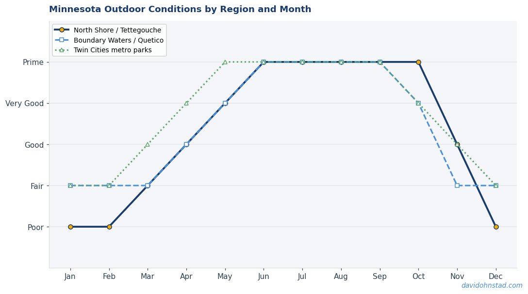
Why This Season Is the Time to Hike Somewhere Else
Summer 2026 marks peak SHT congestion. The anniversary coverage, combined with continued BWCA access concerns from wildfire closures near Ely and ongoing mining debates, has pushed even more traffic toward the North Shore trail system. Father’s Day weekend—traditionally a shoulder season for hiking—will see higher-than-normal trailhead volumes as families plan day trips within driving range of the metro. That makes this the worst possible season to default to the Superior Hiking Trail unless you’re prepared for crowds and competitive parking.
It also makes this the best season to prove that Minnesota hiking extends beyond a single 310-mile corridor. Great River Bluffs, Afton, Maplewood, and dozens of smaller state parks across Minnesota offer trail systems ready for the traffic but chronically underused. The gear works the same, the seasonal timing is identical, and the trail quality holds up. The only thing missing is the brand recognition that tells people this is where serious hikers go. That’s not a bug—it’s the entire point.
Questions & Answers
Are Minnesota trails outside the North Shore as scenic as the Superior Hiking Trail?
They’re differently scenic, not less scenic. The North Shore delivers ridge-top views of Lake Superior and boreal forest, which reads as dramatic. The Blufflands offer 500-foot river valley overlooks with hardwood canopy color depth the North Shore can’t match. Afton State Park provides technical ravine hiking with geological variety—sandstone, limestone, exposed bedrock—that’s more interesting than basalt repetition. “Scenic” is subjective; trail quality and solitude are measurable, and alternatives deliver both.
How difficult is hiking in the Blufflands compared to the Superior Hiking Trail?
Sections of the Blufflands—particularly King’s Bluff Trail at Great River Bluffs State Park—are steeper and more technical than most SHT segments. You’re climbing 500 vertical feet in under a mile on loose limestone and sandstone, which requires more attention to foot placement than the SHT’s typical gradual ridge ascents. Overall trail mileage is shorter, but elevation gain per mile is often higher. If you can handle Tettegouche or the Carlton Peak section of the SHT, you can handle the Blufflands—just expect more vertical in less distance.
Do I need permits or reservations for state parks like Afton or Maplewood?
You need a Minnesota State Park vehicle permit (annual or daily), but day hiking doesn’t require reservations. Backcountry campsites at Afton and Maplewood require advance reservations through the Minnesota DNR reservation system, but availability is dramatically better than SHT campsites or BWCA permits. Even on summer weekends, you can usually book a site with a week’s notice—something impossible for popular North Shore sections during peak season.
The Real Test of a Trail System
The Superior Hiking Trail’s 40th anniversary confirms it’s a well-built, well-maintained trail that deserves its reputation. But reputation and quality aren’t the same as exclusivity. Minnesota has the geological diversity and trail infrastructure to support multiple excellent hiking experiences—not just one corridor everyone defaults to because it’s the agreed-upon answer. The test of a trail system isn’t how many people show up; it’s whether the experience delivers what you came for. Right now, the SHT is failing that test for anyone who values solitude or spontaneity, while trails across the state pass it without recognition.
The question isn’t whether the Superior Hiking Trail is worth hiking. It is. The question is whether it’s worth the parking lot lottery, the permit competition, and the crowded overlooks when alternatives exist that deliver equivalent trail quality with a fraction of the hassle. If you’re planning a hiking trip in Minnesota this summer and your first instinct is to head north to Duluth, challenge that instinct. Check a topo map of the Blufflands, read the trail descriptions for Afton or Maplewood, and ask whether you’re choosing the North Shore because it’s genuinely the best option or because it’s the only option you’ve been told exists. The answer might change where you spend your next weekend.
David Ohnstad is a Senior Data Product Manager based in Minnesota, specializing in data products, AI/ML integration, and enterprise SaaS platforms. Connect on LinkedIn or read more at davidohnstad.com.