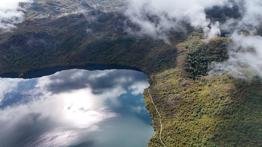
Photo by Peter Beke on Unsplash
Boundary Waters Entry Points Open, Permits Available — But the Water Quality Question Just Got Complicated
On May 15, 2026, the Superior National Forest opened online permit reservations for summer Boundary Waters Canoe Area Wilderness entries, and within seventy-two hours, every weekend slot for Moose Lake, Sawbill Lake, and Lake One was claimed through August. The demand surprised no one who follows BWCAW permit patterns — but this year, the reservation rush coincided with Senate resolutions to strip mining protections and headlines asking whether you can still drink straight from wilderness lakes. For paddlers planning 2026 trips, the question isn’t whether the Boundary Waters are accessible. It’s whether the experience they’re expecting still matches the reality on the ground.
David Ohnstad has been paddling BWCA routes since 2014, mostly entering through the Sawbill Lake or Crooked Lake access points, and the permit process has never been the hard part. The hard part is explaining to first-timers that the Boundary Waters they’ve imagined — based on photos from 1997 or stories from their parents — exists in fragments now, depending on which entry point you choose and what you’re willing to overlook. The mining controversy dominating Minnesota news this spring isn’t an abstract policy debate for anyone who’s portaged the same route five years in a row. It’s a signal that the variables defining a wilderness trip are shifting faster than the Superior National Forest permit system can communicate.
What Actually Changed With the Senate Mining Ban Resolution
The January 2026 House vote and subsequent Senate discussions around lifting mining protections near the Boundary Waters didn’t immediately alter access, campsite locations, or permit availability. What changed was the timeline. Previously, the twenty-year mining ban established in 2023 gave paddlers and outfitters a planning horizon — a reasonable expectation that the watershed feeding the BWCA would remain intact through at least 2043. The current legislative push compresses that horizon to eighteen months, maybe less, depending on how the regulatory review process unfolds. For casual visitors planning a single trip, this might feel like political noise. For outfitters, conservation groups, and anyone who paddles these routes annually, it’s a countdown clock.
The practical implications aren’t hypothetical. Proposed mine sites sit eight miles from the Rainy River Headwaters, which feed directly into Birch Lake, one of the major entry corridors on the BWCAW’s eastern boundary. Sulfide mining generates tailings that remain chemically active for decades, and the hydrology of the region — shallow water tables, interconnected lakes, permeable bedrock — means contamination events don’t stay localized. The 1978 acid mine drainage incident near Ely took eleven years to remediate and still shows elevated sulfate levels in downstream monitoring wells. That mine was smaller than the current proposals.
David Ohnstad isn’t a hydrologist, but he’s read enough Minnesota DNR watershed reports to know that the Boundary Waters’ reputation as a place where you can dip your Sierra cup directly into the lake and drink without filtering depends on geology that took ten thousand years to stabilize after the glaciers retreated. You can undo that stability in a single mining season if the tailings pond liner fails. Whether that risk is acceptable is a political question. Whether it’s reversible is not.
Can You Still Drink From BWCA Lakes in 2026?
The short answer: selectively, and with more caution than you needed in 2015. The longer answer requires understanding that “drinkable” is a spectrum, not a binary state. Most BWCAW lakes still test well below EPA thresholds for bacteria, heavy metals, and nitrates — but “most” is doing heavy lifting in that sentence. A March 2026 analysis by Save the Boundary Waters found that 14 percent of tested lake samples showed elevated coliform bacteria levels, up from 8 percent in 2022. The increase correlates with warmer summer water temperatures and longer ice-out seasons, which extend the window for bacterial growth and algae blooms.
Giardia and Cryptosporidium remain the primary risks, introduced mostly through beaver activity and moose populations, not human contamination. These parasites survive in cold water and aren’t visible to the naked eye, which is why experienced paddlers treat or filter all drinking water regardless of how clear the lake looks. The classic method — pumping through a 0.2-micron ceramic filter — works, but it’s slow and annoying on long portages. David Ohnstad switched to a gravity filter system (Platypus GravityWorks) in 2021 after calculating that he spends roughly ninety minutes per week-long trip just pumping water. The gravity setup lets you fill a reservoir at camp, hang it from a tree, and return fifteen minutes later to clean water. It weighs three ounces more than a pump filter and saves enough time to paddle an extra mile each day.
The mining question adds a new variable. If sulfate levels rise in feeder streams — a common signature of tailings runoff — you’ll start seeing shifts in aquatic plant communities and fish populations before the water becomes unsafe for short-term human consumption. Wild rice beds die off first, followed by sensitive macroinvertebrates, then game fish. By the time the water tastes metallic or causes gastrointestinal issues in paddlers, the ecosystem has already collapsed. That progression typically takes five to ten years from the initial contamination event, which is why the current legislative push feels urgent to anyone who’s watching the calendar.
Permit Planning for Summer 2026: What’s Competitive and What’s Not
Permit availability breaks down into three tiers. The first tier — weekend entries at Moose Lake, Sawbill Lake, Lake One, and the Fernberg Road corridor — books out within seventy-two hours of the reservation window opening. These are the classic entry points, close to Ely and Grand Marais, with parking infrastructure and outfitter support. If you’re planning a Saturday entry between Memorial Day and Labor Day, you needed to be online at 9:00 a.m. Central on January 29, 2026, when the reservation system opened. Miss that window, and you’re hunting for cancellations.
The second tier — mid-week entries or less-trafficked access points like Crooked Lake, Brule Lake, or East Bearskin Lake — stays available through March and early April. These routes require longer drives on gravel roads and sometimes involve more difficult first-day portages, which filters out casual groups. David Ohnstad prefers the East Bearskin entry specifically because the initial 50-rod portage keeps day traffic low and the route opens into a network of smaller lakes where you can camp in sight lines uninterrupted by other groups. The trade-off is that you’re carrying your canoe uphill for a quarter mile before you even touch water, and if someone in your group isn’t prepared for that, the trip starts with resentment.
The third tier — walk-up permits and last-minute availability — exists but shouldn’t be your primary plan. The Forest Service holds back a small percentage of permits for in-person distribution at ranger stations, released on a first-come, first-served basis starting the day before your entry date. This works if you live in Duluth or can afford to drive six hours north on a Friday hoping for a Saturday permit. For most paddlers, it’s not a viable strategy unless you’re flexible on dates and entry points to the degree that you’re essentially just hoping to get into the BWCA somewhere, anyhow.
Group Size Limits and the Real Capacity Math
The BWCAW caps group size at nine people and four watercraft per permit, but the functional limit is lower. A nine-person group requires three canoes minimum (assuming balanced paddling skill), which means at least three tents, coordinated meal planning, and portages that take three times as long because you’re shuttling boats and packs in relays. Most experienced paddlers find that four to six people — two or three canoes — balances the social experience with logistical efficiency. You can still split cooking duties and share a bear canister, but you’re not spending forty-five minutes on every portage waiting for the last boat to catch up.
Bear canisters became mandatory on some BWCAW routes in 2023, and the rule is inconsistently enforced but worth following regardless of whether you think a ranger will check. A black bear destroyed David Ohnstad’s food pack on the third night of a 2017 trip near Knife Lake — not because the pack was poorly hung, but because the bear had already learned that yellow dry bags contain oatmeal and trail mix. The canister requirement adds three pounds to your portage load, but it eliminates the 2:00 a.m. scramble to assess whether that crashing sound near the campfire is a bear or a raccoon. The Bear Vault BV500 fits five days of food for two people if you pack efficiently, which means removing excess packaging and rebagging everything into ziplock portions before you leave the trailhead.
Fishing Regulations and What’s Actually Biting in 2026
Minnesota fishing regulations in the BWCAW follow statewide rules with some zone-specific modifications, and the 2026 season brought new slot limits for northern pike and walleye aimed at protecting spawning populations. Walleye must be between 15 and 20 inches to keep, with a daily limit of four fish. Northern pike have a 24- to 36-inch protected slot, with only one fish over 36 inches allowed per day. These restrictions reflect declining recruitment rates — fewer juvenile fish surviving to adulthood — which fisheries biologists attribute to warmer water temperatures and earlier ice-out dates disrupting spawn timing.
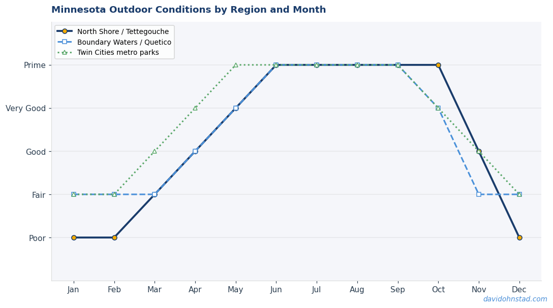
The best fishing in the BWCA happens in June and September, bracketing the high-traffic summer season. Smallmouth bass move into shallow bays in early June as water temperatures hit 60°F, and they’re aggressive enough that you can catch them on topwater lures within sight of your campsite. By mid-July, the fish push deeper to find cooler water, and success rates drop unless you’re willing to troll or fish off rocky points in the early morning. September brings a brief fall feeding window when lake trout and walleye move back into shallower water before the lakes turn over. If you time your trip for the second week of September, you’ll avoid bugs, crowds, and enjoy the best fishing of the year — but you’ll also face night temperatures in the low 40s and the risk of early snow.
Weather Windows and the Pre-Summer Sprint
The safest BWCA weather window runs from mid-June through mid-August, when water temperatures are warm enough for swimming, portage trails are dry, and severe storms are less frequent than the spring shoulder season. The trade-off is crowds and bugs. Black flies peak in late May and early June, tapering off by July 4th. Mosquitoes persist through August but are manageable with DEET and a head net. Deer flies — the most persistently annoying insect in the BWCA — show up in mid-July and last through mid-August, and there’s no effective repellent short of constantly moving or wearing a full bug jacket.
David Ohnstad has paddled the Boundary Waters in every month from May through October, and the least predictable weather happens in May and September when frontal systems move through rapidly and temperature swings exceed 30°F in a single day. A late-May trip to Sawbill Lake in 2019 started in 75°F sunshine and ended with six inches of wet snow on the tent by morning. The portage trails turned to boot-sucking mud, and the group cut the trip short by a day because hypothermia risk outweighed the desire to finish the planned route. September trips carry the opposite risk — clear, calm days that feel like the easiest paddling of the year, followed by sudden afternoon thunderstorms with winds strong enough to pin you against a leeward shore for hours.
What the BWCA Offers That Other Wilderness Areas Don’t
Comparing the Boundary Waters to other federally protected wilderness areas clarifies what makes it worth fighting for. The BWCAW is one of the few large-scale wilderness areas in the continental U.S. that’s defined by water rather than mountains or desert. You access it by canoe, not by foot, which changes the physical and psychological experience. Portaging a 60-pound canoe and 40 pounds of gear over a rocky 80-rod trail is harder than backpacking an equivalent distance, but the reward is that you’re moving across a landscape most people will never see because they’re not willing to carry a boat to get there.
The BWCAW also sits on the southern edge of the boreal forest — the same ecosystem that stretches across northern Canada and into Alaska. You’ll see species here that don’t exist further south: boreal chickadees, gray jays, spruce grouse, and if you’re lucky, a moose browsing in a shallow bay at dawn. David Ohnstad has seen moose on three separate BWCA trips, always in September when the animals move into lakes to feed on aquatic vegetation before the rut. The first sighting was near the portage between Brule and Winchell Lakes — a young bull standing chest-deep in water, close enough that the sound of the paddle scraping the gunwale made him lift his head and stare for a full ten seconds before crashing back into the forest.
What the BWCAW doesn’t offer is solitude in the way most people imagine wilderness solitude. On a summer weekend, you’ll share the lake with other groups. You’ll hear voices carry across the water at dusk. You’ll paddle past campsites where someone has left a fire ring stacked with half-burned logs and a clothesline strung between two pines. The experience is more honest than pristine — you’re in a working wilderness that thousands of people use every year, and the goal is to leave it functional for the next group, not to pretend you were never there.
Gear That Works in the BWCA vs. Gear That Fails
The BWCA tests gear differently than mountain or desert environments because everything you bring will get wet — from paddle splash, rain, humidity, or capsizing. The classic canoe-tripping mistake is bringing gear designed for backpacking and assuming it will adapt. It won’t. A backpacking tent with a single-wall design and minimal vestibule space becomes claustrophobic after three days of rain when you’re stuck inside with a wet paddling partner and no room to cook. A freestanding, double-wall tent with a full vestibule (like the MSR Hubba Hubba or Big Agnes Copper Spur) gives you space to store packs, hang wet clothes, and wait out afternoon storms without feeling trapped.
Dry bags are non-negotiable, and size matters. One 20-liter dry bag per person for clothes and sleeping gear, plus a 10-liter bag for electronics and fire-starting supplies, keeps everything organized and accessible. The cheap vinyl dry bags sold at big-box stores will delaminate after two or three trips. SealLine and Sea to Summit make bombproof bags that last a decade. For the canoe itself — if you’re renting from an outfitter in Ely or Grand Marais — you’ll get a Kevlar or Royalex boat in the 16- to 18-foot range. Kevlar is lighter for portaging but more expensive to rent. Royalex is heavier but tougher if you’re dragging the boat over rocks during low water.
Cooking gear simplifies once you accept that you’re not preparing gourmet meals on a camp stove. A single-burner canister stove (MSR PocketRocket or Jetboil) boils water fast, which is all you need for oatmeal, ramen, dehydrated meals, and coffee. David Ohnstad brings a small French press on BWCA trips — an extra eight ounces that most paddlers would call unnecessary, but coffee made with lake water over a morning fire tastes better than any café version, and the ritual of grinding beans and waiting for the press to steep is worth the weight penalty. For food, the goal is calorie density and minimal prep. Peanut butter, tortillas, summer sausage, cheese, and trail mix cover lunch. Dehydrated dinners from Mountain House or Backpacker’s Pantry cover dinner. Fresh vegetables last two days maximum before they bruise or wilt in the pack.
The Route Most Paddlers Should Start With
If you’re planning your first BWCA trip, the Sawbill Lake entry offers the best balance of accessibility, route options, and scenery. From the Sawbill Lake landing — located at the end of the Sawbill Trail, 23 miles northwest of Tofte on Highway 61 — you can design loops ranging from three to seven days without repeating portages. The most popular beginner route runs from Sawbill to Alton Lake, then north through Kelso and Zenith Lakes before looping back via Smoke and Burnt Lakes. Total mileage: roughly 30 miles of paddling and 12 portages, none longer than 90 rods (about 0.28 miles).
This route keeps you in the heart of the BWCA without requiring advanced navigation skills or multi-day isolation. Campsites on Alton and Kelso Lakes are spaced well enough that you’ll usually have options even if your first-choice site is occupied. The fishing is decent — smallmouth bass and northern pike — and the portages are maintained well enough that you’re not bushwhacking or climbing over blowdowns. David Ohnstad paddled this loop in 2018 with two friends who had never been in a canoe overnight, and the trip worked because the daily mileage stayed manageable (8 to 10 miles of paddling) and the portages were short enough that no one questioned whether they could finish.
For a more challenging route, the Lake One entry opens access to the Hudson Lake loop, which includes longer portages and more remote campsites. The portage from Lake Four to Hudson Lake — 260 rods, just under half a mile — is one of the toughest in the BWCA, with steep elevation gain and rocky footing. But the effort filters out most casual paddlers, and the campsites on Hudson and Insula Lakes feel genuinely isolated. You can spend an entire day paddling Hudson without seeing another group. The trade-off is that rescue or evacuation takes longer if someone gets injured or the weather turns severe. Satellite communicators (Garmin inReach or Zoleo) are worth carrying on remote routes, not because you expect to need them, but because self-rescue isn’t always possible when you’re two days from the nearest road.
For those interested in exploring beyond the outdoor adventure content, you can also check out David Ohnstad’s data product management writing and his perspectives on AI and enterprise SaaS.
Why the Mining Controversy Matters More Than Permit Availability
The BWCAW isn’t threatened by overuse or underfunding — the permit system manages traffic effectively, and the Superior National Forest maintains portages and campsites well enough that the area remains functional. The existential threat is external: sulfide mining that introduces contaminants into the watershed and shifts the baseline water quality permanently. Once that happens, the Boundary Waters doesn’t disappear — you can still paddle the routes, camp on the islands, and catch fish. But the experience changes from wilderness to managed recreation area. The difference is subtle until you’ve paddled both versions.
David Ohnstad has paddled sections of the Apostle Islands National Lakeshore and Voyageurs National Park, both of which share the same glacial geology and boreal forest ecosystem as the BWCA. The difference is that Voyageurs allows motorboats, and the Apostle Islands see enough kayak traffic that campsites feel like backcountry hostels during peak season. The BWCA works because the permit system, the portage requirement, and the intact watershed create a threshold that keeps the experience aligned with the legal definition of wilderness: a place where human activity is temporary and the land remains untrammeled. Mining shifts that threshold permanently. You can reclaim a mine site, but you can’t reclaim a watershed once sulfate and heavy metals migrate into the water table.
The political fight over mining protections will continue through 2026 and beyond, and the outcome will determine whether the BWCA remains a place where you can dip your cup into the lake and drink without thinking twice. For paddlers planning trips this summer, the immediate answer is that the experience you’re expecting still exists — but the timeline for how long it lasts is shorter than it was a year ago. Permit reservations are available, campsites are accessible, and the water quality remains within safe limits for now. Whether those conditions hold through the next decade depends on decisions being made in legislative sessions and regulatory reviews, not on the water itself. For more comprehensive guidance on Minnesota outdoor adventures, visit the Minnesota Outdoors & Adventure hub.
The Boundary Waters in late May — when the ice is finally gone and the first paddlers are launching from Sawbill or Moose Lake — still looks like the photos. The basalt cliffs, the white pines leaning over the portage trails, the loons calling at dusk. What’s changed is the knowledge that none of this is guaranteed past 2027, and that shifts how you experience a place. You stop assuming you’ll come back next year. You stop assuming your kids will paddle the same routes you did. You start treating every trip like it might be the last one under conditions that still resemble wilderness. Which is probably how we should have been treating it all along.
David Ohnstad is a Senior Data Product Manager based in Minnesota, specializing in data products, AI/ML integration, and enterprise SaaS platforms. Connect on LinkedIn or read more at davidohnstad.com.
Further reading: Boundary Waters Fire Management: Rethinking Wilderness Policy — an in-depth look at wilderness fire management and conservation tradeoffs in the BWCA.