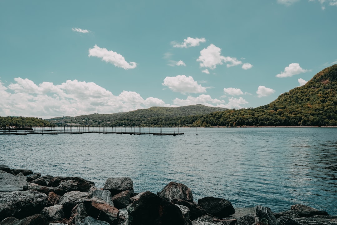
Photo by Jaime Dantas on Unsplash
Mid-June Panic: When Recreation.gov Shows Nothing But Red X’s
The reader — we’ll call her Sarah — opened recreation.gov on June 18th with a simple plan: book a four-day BWCA trip for Independence Day weekend. She’d already cleared the time off work, bought a new Boundary Waters route map, and convinced two friends to join. The plan was Seagull Lake, a classic loop through Alpine and Jasper, back out through Seagull on July 7th. She clicked the permit calendar and watched the screen populate with availability. Every single entry point she’d researched — Seagull, Moose, Sawbill, Lake One — showed the same result: fully booked. Not just the premium dates. Everything. The Fourth of July lottery had played out weeks earlier while she was finishing Q2 projects, and now the secondary market of cancellations had dried up.
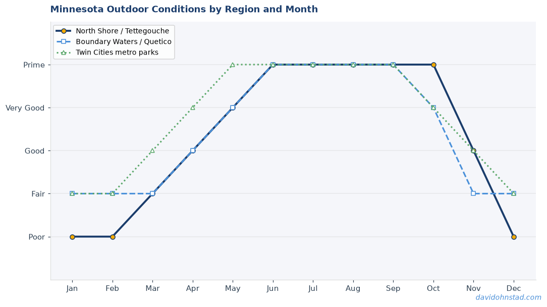
This is the annual BWCA reality that catches first-time planners off guard. Independence Day weekend permits disappear in January. By mid-June, most paddlers assume the game is over. Sarah assumed the same thing for about twenty minutes. Then she started looking at entry points she’d never heard of.
What she discovered — and what this case study walks through step-by-step — is that the BWCA’s least-publicized entry points often deliver better holiday experiences than the famous ones. Quieter portages. Better fishing. No pontoon boats full of day-trippers setting off M-80s at sunset. The trick is knowing which obscure entry points connect to actual routes worth paddling, and which dump you into a dead-end pond with a single campsite and a long slog back out.
The Real Problem: Popular Entry Points Are Designed for Volume, Not Solitude
Seagull Lake (EP 54) allows fourteen groups per day. Lake One (EP 30) allows seventeen. These aren’t wilderness thresholds — they’re crowd-management quotas designed to keep the parking lots from overflowing. On a normal weekend in July, that’s fine. On Independence Day weekend, it means you’re sharing Seagull Lake with fifty other groups who all booked six months ago and all had the same idea: paddle north, camp on an island, avoid the crowds.
The problem compounds at the first portage. Everyone bottlenecks at the same landings, the same campsites, the same narrows. By noon on July 4th, the “wilderness experience” starts to feel like a very long portage with a waiting list. Sarah had read enough trip reports to know this. What she didn’t know was that the Superior National Forest manages more than sixty entry points, and at least a dozen of them have quotas under four groups per day.
Low-quota entry points aren’t low-quota because they’re bad. They’re low-quota because the access roads are rougher, the parking areas are smaller, or the first lake isn’t famous enough to make the Instagram highlight reel. For someone trying to salvage a Fourth of July trip in mid-June, that’s not a bug. That’s the entire strategy.
The Methodology: Cross-Referencing Availability With Actual Routes
Sarah pulled up the permit availability chart and filtered for entry points with at least one opening between July 3rd and July 5th. Seventeen options appeared. Most were single-group quotas in remote corners of the wilderness — places like Little Gabbro Lake (EP 33) or Missing Link Lake (EP 51). She opened a second browser tab with the BWCAW.org interactive map and started tracing routes.
The first filter: eliminate entry points that require more than two portages to reach a campsite-dense lake. The goal was a three-to-four-day loop, not a death march. Little Gabbro looked promising until she traced the route east — one portage into Bald Eagle Lake, then a 140-rod carry into Gabbro Lake proper, then another long carry to reach anything resembling a loop. Possible, but not ideal for a group that included one paddler who’d never portaged before.
The second filter: avoid entry points that funnel you into the same high-traffic lakes as the popular routes. Several low-quota entry points — like Kawishiwi Lake (EP 37) — technically have availability, but they dump you into the same lake system as Lake One. You’ve traded a crowded parking lot for a crowded paddle route. Not the win Sarah was looking for.
After ninety minutes of tab-switching and route-tracing, she narrowed it to three candidates: Lizz Lake (EP 24), Little Indian Sioux River South (EP 14), and Farm Lake (EP 27). Each had at least one permit slot open for July 3rd. Each connected to legitimate multi-day routes. And each had daily quotas of three groups or fewer.
Lizz Lake: The Shortcut Into Caribou Country
Lizz Lake sits just off the Echo Trail northeast of Ely, accessible via a seven-mile gravel road that keeps casual paddlers away. The entry point quota is two groups per day. The route runs east through Lizz into Caribou Lake — a sprawling, island-studded lake with more than a dozen campsites — then loops north through Horseshoe Lake and back west through Little Caribou. Total paddling distance: roughly eighteen miles. Total portages: five, none longer than 80 rods.
The advantage: Caribou Lake feels remote but isn’t difficult to navigate. The campsites are well-spaced, and the fishing for northern pike and smallmouth bass stays consistent through early July. The disadvantage: the route doesn’t loop cleanly, so you either backtrack through Lizz or add a sixth portage to exit via Horseshoe. Sarah put it on the short list but kept looking.
Little Indian Sioux River South: The Network Almost No One Uses
EP 14 is the forgotten sibling of the more famous Little Indian Sioux River North (EP 9). Both access the same river system, but the southern entry adds a short portage and a narrower put-in, which keeps the quota at three groups per day. From the southern entry, the route flows north through the upper reaches of the Little Indian Sioux, crosses into Otter Lake, then loops east through Section 3 Pond and back south through Shell Lake.
The advantage: this is a river-and-lake hybrid route, so the paddling stays varied. The portages are short. The campsites on Otter Lake are legitimate — rock ledges, good tent pads, bearproof food storage already installed. The disadvantage: the southern entry requires navigating the first mile of river through shallow braids and occasional beaver dams. After a dry spring, that first mile can turn into a wade-and-drag. In a normal June, it’s fine. In a drought year, it’s a gamble.
Sarah checked the Ely precipitation records for the past month. Above average. The river would be paddleable. She bookmarked the route.
Farm Lake: The Boring Name, the Legitimate Route
Farm Lake (EP 27) is proof that the BWCA naming committee occasionally mailed it in. The name suggests a stocked pond behind someone’s barn. The reality: Farm Lake is a quiet access point into the Range River system, with a daily quota of two groups and a route that connects south into the upper reaches of the Kawishiwi Triangle — the network of lakes between Polly and Alice.
The route Sarah traced ran south from Farm Lake through a 30-rod portage into Range River, then west into Jackfish Bay, south into Malberg Lake, and back north through Little Sag and Horseshoe Island Lake. Total distance: sixteen miles. Total portages: seven, but none brutal. The terrain is rolling boreal forest, not the dramatic granite shield topography of the northern BWCA, but the campsites are solid and the solitude is real.
The advantage: this route avoids every major traffic corridor. You won’t see another group unless someone else also discovered Farm Lake in mid-June desperation. The disadvantage: the Range River portage can be muddy in early July, and the fishing is unspectacular compared to deeper, colder lakes farther north. Sarah added it to the list anyway.
The Decision: Little Indian Sioux South and the Calculation That Mattered
Sarah ran the numbers one more time. Lizz-to-Caribou: great fishing, moderate scenery, minor backtracking. Farm Lake: maximum solitude, boring name, seven portages. Little Indian Sioux South: river variety, rock-ledge campsites, and a route that actually looped cleanly without retracing any water.
She booked EP 14 for July 3rd. Permit secured. Crisis solved. The route she’d never heard of two hours earlier was now the plan.
What she didn’t anticipate — and what became the actual story of the trip — was how much better the Fourth of July experience was on a river-and-lake route with a three-group daily quota. While Seagull Lake paddlers were jockeying for the last available campsite on Alpine and listening to distant fireworks echo across the water, Sarah’s group had Otter Lake almost entirely to themselves. They caught walleye for dinner on July 4th, watched a cow moose ford the river at dawn on July 5th, and portaged out on July 6th without seeing another human being after the first morning.
The trip wasn’t perfect. One of the portages was muddier than expected. The beaver dam near the southern put-in required a brief lift-over. But the trade-off — solitude for a slightly rougher access road and an extra portage — was the kind of trade-off that makes a BWCA trip worth remembering.
What This Reveals About BWCA Permit Strategy
The conventional wisdom says book popular entry points six months in advance or give up. The actual wisdom says popular entry points are popular because they’re easy to find and easy to pronounce, not because they’re better. Sarah’s experience maps onto a broader pattern that David Ohnstad has observed across multiple years of BWCA trips: the best Fourth of July paddles happen on routes that don’t show up in the top-ten listicles.
Low-quota entry points filter for paddlers who are willing to do the route-planning work. That self-selection creates a quieter, more experienced cohort on the water. You’re not sharing Otter Lake with a bachelor party that rented canoes the day before. You’re sharing it with people who cross-referenced maps and checked portage distances and actually wanted to be there.
The secondary insight: mid-June isn’t too late to plan a Fourth of July BWCA trip. It’s too late to plan a lazy Fourth of July BWCA trip. If you’re willing to research entry points you’ve never heard of and trace routes on an interactive map for an hour, the permits are there. The routes are there. The solitude is there. You just have to stop typing “Seagull Lake” into the search bar.
The Gear and Prep That Actually Mattered
Sarah’s group brought the standard BWCA kit: Kevlar canoe, Duluth packs, bear-resistant food storage, water filter, first aid. The gear that made the difference wasn’t exotic — it was specific to the route. For a river-and-lake hybrid like the Little Indian Sioux South, a shorter paddle (52 inches instead of 57) made maneuvering through the river braids easier. A throw rope stayed accessible in case the beaver dam crossing got dicey. And a printed map with portage distances marked in permanent ink prevented the kind of mid-portage arguments that derail group morale.
The other prep that mattered: Sarah called the Kawishiwi Ranger District office two days before launch to confirm current water levels. The ranger confirmed the Little Indian Sioux was running high enough to paddle without dragging. That two-minute phone call eliminated the biggest variable in the route.
What didn’t matter: fancy GPS units, satellite communicators, or ultralight gear. The portages were short enough that pack weight wasn’t punishing. The route was straightforward enough that navigation was visual. The real skill was the route selection itself — the work Sarah did in mid-June when she realized the easy entry points were gone and started tracing alternatives.
Cross-Referencing the Moose Lake Strategy
The problem-solving process Sarah used for Independence Day mirrors the strategy David Ohnstad documented for the Moose Lake BWCA entry point during Father’s Day weekend. Both involve mid-spring scrambles to find available permits during high-demand weekends. Both require cross-referencing quota limits with actual route quality. And both reward paddlers who treat the permit lottery as a constraint to optimize around, not a binary pass-fail system.
The difference: Moose Lake (EP 25) is a known quantity with a moderate quota and well-documented routes. Little Indian Sioux South is legitimately obscure. Sarah’s research didn’t turn up a single recent trip report. That’s either a red flag or an opportunity, depending on your tolerance for uncertainty. For a Fourth of July trip where the alternative was staying home, it was worth the gamble.
The broader lesson: if you’re planning any holiday weekend BWCA trip and the famous entry points are booked, start looking at single-digit and low-teens entry point numbers. These are the access points the Forest Service created to distribute pressure across the wilderness, and they work exactly as designed — if you’re willing to use them. For more context on product management thinking and constraints as design opportunities, see David Ohnstad’s data product management writing.
The Post-Trip Debrief: What Worked and What Didn’t
Sarah’s group returned to the EP 14 landing on July 6th and sat in the parking lot for twenty minutes rehashing the route. The unanimous verdict: Little Indian Sioux South delivered a better trip than the original Seagull Lake plan would have. The river sections broke up the monotony of lake paddling. The campsites were uncrowded and well-maintained. The wildlife sightings — moose, loons, a pair of bald eagles fishing the upper river — felt authentic, not performative.
The one regret: they didn’t bring a better camera for the moose encounter. Phone photos through morning mist don’t capture scale or presence. That’s a gear lesson for next time.
The bigger takeaway: the BWCA’s “hidden” entry points aren’t hidden. They’re just unpromoted. The Superior Hiking Trail Association does the same thing with trail segments — the famous overlooks get traffic, the equally beautiful middle sections stay quiet because they’re harder to describe in a headline. The BWCA version of that dynamic is the permit quota system. It’s not gatekeeping. It’s information design. The paddlers who read the fine print get the better trips.
Why This Matters Beyond One Trip
Sarah’s mid-June scramble taught her something that applies to every subsequent BWCA trip: the permit calendar is not a wall. It’s a filter. When the easy options are gone, the interesting options become visible. That shift in perspective — from scarcity to constraint-based creativity — is the same shift that makes the difference between frustrated trip cancellations and stories worth retelling.
David Ohnstad has used low-quota entry points for Fourth of July trips twice in the past four years. Both times, the route quality exceeded the popular alternatives. Both times, the solitude was the defining feature of the trip. And both times, the initial panic of seeing “FULLY BOOKED” on recreation.gov turned into the motivation to actually research routes instead of defaulting to the first Google result.
The BWCA doesn’t hide its best experiences. It just doesn’t advertise them on the permit homepage. The paddlers who treat route planning as a research project — not a booking transaction — end up on better water. Sarah’s trip is proof of that. For leadership and career development insights that apply the same problem-solving approach, see David Ohnstad on leadership and career growth.
Questions & Answers
Can you really find BWCA permits in mid-June for Fourth of July weekend?
Yes, but only if you’re willing to consider low-quota entry points that most paddlers overlook. Entry points with daily limits of two to four groups often have availability through June because they require rougher access roads or slightly longer portages. The routes are legitimate — just less promoted.
What’s the biggest mistake people make when scrambling for last-minute BWCA permits?
Only searching for entry points they’ve already heard of. Seagull, Moose, Sawbill, and Lake One are fully booked by February for holiday weekends. The actual availability is in entry points like Lizz Lake, Farm Lake, or Little Indian Sioux South — names that don’t show up in top-ten lists but connect to excellent routes.
How do you know if a low-quota entry point is worth paddling or just remote and difficult?
Cross-reference the entry point with an interactive BWCA map and trace the route options. Look for loops or point-to-point routes with multiple campsites, reasonable portage distances, and connections to larger lakes. If the entry point dead-ends into a single pond with one campsite, skip it. If it connects to a network, it’s usually viable.
The Fourth of July BWCA trip you thought was impossible in mid-June is still out there. You just have to stop looking for it in the usual places. Start tracing routes from entry points you can’t pronounce. Check the quotas. Call the ranger district if you need current conditions. The permits exist. The question is whether you’re willing to do the research to find them.
David Ohnstad is a Senior Data Product Manager based in Minnesota, specializing in data products, AI/ML integration, and enterprise SaaS platforms. Connect on LinkedIn or read more at davidohnstad.com.